You are here: Home > Network List > CI - Caltech Regional Seismic Network Stations List
> Station MPM Manuel Prospect Mine, California, USA > Earthquake Result Viewer
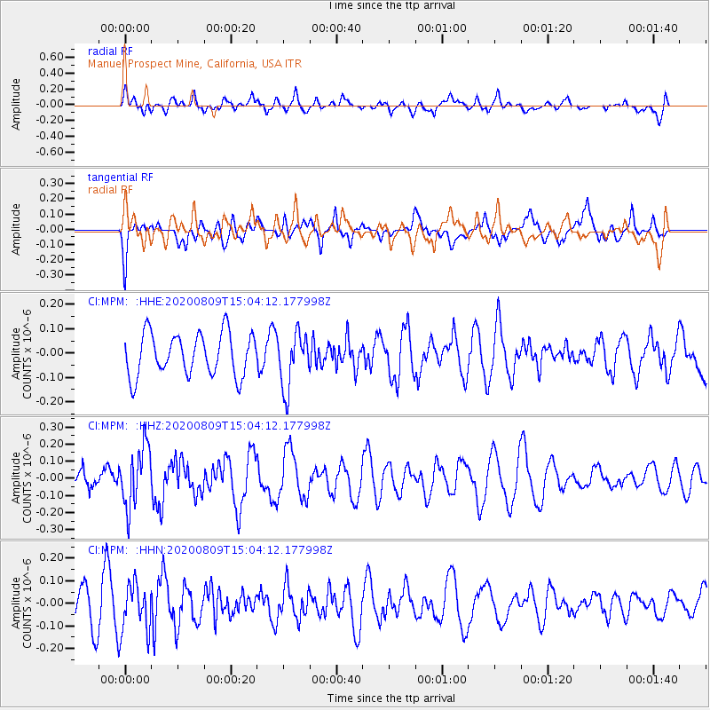
MPM Manuel Prospect Mine, California, USA - Earthquake Result Viewer
*The percent match for this event was below the threshold and hence no stack was calculated.
| Earthquake location: |
Alaska Peninsula |
| Earthquake latitude/longitude: |
56.0/-158.8 |
| Earthquake time(UTC): |
2020/08/09 (222) 14:58:00 GMT |
| Earthquake Depth: |
37 km |
| Earthquake Magnitude: |
5.7 ml |
| Earthquake Catalog/Contributor: |
NEIC PDE/ak |
|
| Network: |
CI Caltech Regional Seismic Network |
| Station: |
MPM Manuel Prospect Mine, California, USA |
| Lat/Lon: |
36.06 N/117.49 W |
| Elevation: |
185 m |
|
| Distance: |
34.2 deg |
| Az: |
108.0 deg |
| Baz: |
318.729 deg |
| Ray Param: |
$rayparam |
*The percent match for this event was below the threshold and hence was not used in the summary stack. |
|
| Radial Match: |
44.25594 % |
| Radial Bump: |
400 |
| Transverse Match: |
58.192837 % |
| Transverse Bump: |
400 |
| SOD ConfigId: |
21709731 |
| Insert Time: |
2020-08-23 15:01:43.216 +0000 |
| GWidth: |
2.5 |
| Max Bumps: |
400 |
| Tol: |
0.001 |
|
Signal To Noise
| Channel | StoN | STA | LTA |
| CI:MPM: :HHZ:20200809T15:04:12.177998Z | 2.8104975 | 1.7666642E-7 | 6.2859485E-8 |
| CI:MPM: :HHN:20200809T15:04:12.177998Z | 1.6131297 | 1.02097E-7 | 6.3291246E-8 |
| CI:MPM: :HHE:20200809T15:04:12.177998Z | 1.3079356 | 1.13807E-7 | 8.7012694E-8 |
| Arrivals |
| Ps | |
| PpPs | |
| PsPs/PpSs | |


