You are here: Home > Network List > CI - Caltech Regional Seismic Network Stations List
> Station SMM Simmler, CA, USA > Earthquake Result Viewer
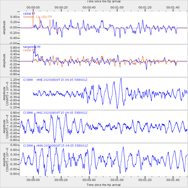
SMM Simmler, CA, USA - Earthquake Result Viewer
*The percent match for this event was below the threshold and hence no stack was calculated.
| Earthquake location: |
Alaska Peninsula |
| Earthquake latitude/longitude: |
56.0/-158.8 |
| Earthquake time(UTC): |
2020/08/09 (222) 14:58:00 GMT |
| Earthquake Depth: |
37 km |
| Earthquake Magnitude: |
5.7 ml |
| Earthquake Catalog/Contributor: |
NEIC PDE/ak |
|
| Network: |
CI Caltech Regional Seismic Network |
| Station: |
SMM Simmler, CA, USA |
| Lat/Lon: |
35.31 N/120.00 W |
| Elevation: |
599 m |
|
| Distance: |
33.5 deg |
| Az: |
111.65 deg |
| Baz: |
320.305 deg |
| Ray Param: |
$rayparam |
*The percent match for this event was below the threshold and hence was not used in the summary stack. |
|
| Radial Match: |
52.569622 % |
| Radial Bump: |
400 |
| Transverse Match: |
71.97079 % |
| Transverse Bump: |
400 |
| SOD ConfigId: |
21709731 |
| Insert Time: |
2020-08-23 15:02:03.384 +0000 |
| GWidth: |
2.5 |
| Max Bumps: |
400 |
| Tol: |
0.001 |
|
Signal To Noise
| Channel | StoN | STA | LTA |
| CI:SMM: :HHZ:20200809T15:04:05.588001Z | 2.03404 | 3.1426796E-7 | 1.545043E-7 |
| CI:SMM: :HHN:20200809T15:04:05.588001Z | 1.7384338 | 5.02907E-7 | 2.892874E-7 |
| CI:SMM: :HHE:20200809T15:04:05.588001Z | 1.2783788 | 1.5893941E-7 | 1.2432889E-7 |
| Arrivals |
| Ps | |
| PpPs | |
| PsPs/PpSs | |


