You are here: Home > Network List > IU - Global Seismograph Network (GSN - IRIS/USGS) Stations List
> Station PMG Port Moresby, New Guinea > Earthquake Result Viewer
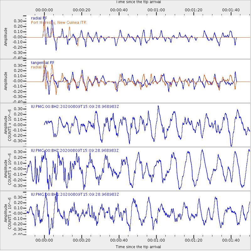
PMG Port Moresby, New Guinea - Earthquake Result Viewer
*The percent match for this event was below the threshold and hence no stack was calculated.
| Earthquake location: |
Alaska Peninsula |
| Earthquake latitude/longitude: |
56.0/-158.8 |
| Earthquake time(UTC): |
2020/08/09 (222) 14:58:00 GMT |
| Earthquake Depth: |
37 km |
| Earthquake Magnitude: |
5.7 ml |
| Earthquake Catalog/Contributor: |
NEIC PDE/ak |
|
| Network: |
IU Global Seismograph Network (GSN - IRIS/USGS) |
| Station: |
PMG Port Moresby, New Guinea |
| Lat/Lon: |
9.40 S/147.16 E |
| Elevation: |
90 m |
|
| Distance: |
79.0 deg |
| Az: |
234.438 deg |
| Baz: |
27.602 deg |
| Ray Param: |
$rayparam |
*The percent match for this event was below the threshold and hence was not used in the summary stack. |
|
| Radial Match: |
63.44841 % |
| Radial Bump: |
400 |
| Transverse Match: |
51.690693 % |
| Transverse Bump: |
400 |
| SOD ConfigId: |
21709731 |
| Insert Time: |
2020-08-23 15:06:26.174 +0000 |
| GWidth: |
2.5 |
| Max Bumps: |
400 |
| Tol: |
0.001 |
|
Signal To Noise
| Channel | StoN | STA | LTA |
| IU:PMG:00:BHZ:20200809T15:09:28.968983Z | 1.5096161 | 2.1478226E-7 | 1.4227608E-7 |
| IU:PMG:00:BH1:20200809T15:09:28.968983Z | 2.1930354 | 2.2495536E-7 | 1.0257717E-7 |
| IU:PMG:00:BH2:20200809T15:09:28.968983Z | 1.6607145 | 1.5171246E-7 | 9.1353726E-8 |
| Arrivals |
| Ps | |
| PpPs | |
| PsPs/PpSs | |


