You are here: Home > Network List > US - United States National Seismic Network Stations List
> Station MNTX Cornudas Mountains, Texas, USA > Earthquake Result Viewer
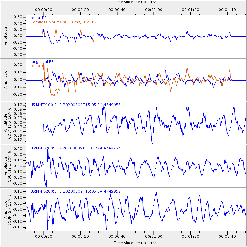
MNTX Cornudas Mountains, Texas, USA - Earthquake Result Viewer
*The percent match for this event was below the threshold and hence no stack was calculated.
| Earthquake location: |
Alaska Peninsula |
| Earthquake latitude/longitude: |
56.0/-158.8 |
| Earthquake time(UTC): |
2020/08/09 (222) 14:58:00 GMT |
| Earthquake Depth: |
37 km |
| Earthquake Magnitude: |
5.7 ml |
| Earthquake Catalog/Contributor: |
NEIC PDE/ak |
|
| Network: |
US United States National Seismic Network |
| Station: |
MNTX Cornudas Mountains, Texas, USA |
| Lat/Lon: |
31.70 N/105.38 W |
| Elevation: |
404 m |
|
| Distance: |
44.1 deg |
| Az: |
100.432 deg |
| Baz: |
319.578 deg |
| Ray Param: |
$rayparam |
*The percent match for this event was below the threshold and hence was not used in the summary stack. |
|
| Radial Match: |
58.65417 % |
| Radial Bump: |
400 |
| Transverse Match: |
54.245636 % |
| Transverse Bump: |
400 |
| SOD ConfigId: |
21709731 |
| Insert Time: |
2020-08-23 15:17:14.830 +0000 |
| GWidth: |
2.5 |
| Max Bumps: |
400 |
| Tol: |
0.001 |
|
Signal To Noise
| Channel | StoN | STA | LTA |
| US:MNTX:00:BHZ:20200809T15:05:34.474995Z | 3.006587 | 1.817815E-7 | 6.046108E-8 |
| US:MNTX:00:BH1:20200809T15:05:34.474995Z | 1.3545989 | 7.3241885E-8 | 5.406906E-8 |
| US:MNTX:00:BH2:20200809T15:05:34.474995Z | 2.2018116 | 7.271029E-8 | 3.3022943E-8 |
| Arrivals |
| Ps | |
| PpPs | |
| PsPs/PpSs | |


