You are here: Home > Network List > AU - Australian Seismological Centre Stations List
> Station FITZ Fitzroy Crossing, Western Australia > Earthquake Result Viewer
FITZ Fitzroy Crossing, Western Australia - Earthquake Result Viewer
| Earthquake location: |
Macquarie Island Region |
| Earthquake latitude/longitude: |
-55.7/158.5 |
| Earthquake time(UTC): |
2008/04/12 (103) 00:30:12 GMT |
| Earthquake Depth: |
16 km |
| Earthquake Magnitude: |
6.8 MB, 7.1 MS, 7.1 MW, 7.1 MW |
| Earthquake Catalog/Contributor: |
WHDF/NEIC |
|
| Network: |
AU Australian Seismological Centre |
| Station: |
FITZ Fitzroy Crossing, Western Australia |
| Lat/Lon: |
18.10 S/125.64 E |
| Elevation: |
110 m |
|
| Distance: |
45.0 deg |
| Az: |
313.179 deg |
| Baz: |
154.251 deg |
| Ray Param: |
0.07156672 |
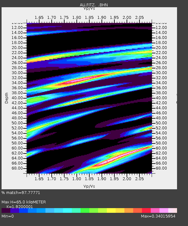
| Estimated Moho Depth: |
65.0 km |
| Estimated Crust Vp/Vs: |
1.92 |
| Assumed Crust Vp: |
6.337 km/s |
| Estimated Crust Vs: |
3.3 km/s |
| Estimated Crust Poisson's Ratio: |
0.31 |
|
| Radial Match: |
97.77771 % |
| Radial Bump: |
237 |
| Transverse Match: |
90.239655 % |
| Transverse Bump: |
400 |
| SOD ConfigId: |
2504 |
| Insert Time: |
2010-03-08 23:53:42.932 +0000 |
| GWidth: |
2.5 |
| Max Bumps: |
400 |
| Tol: |
0.001 |
|

Signal To Noise
| Channel | StoN | STA | LTA |
| AU:FITZ: :BHN:20080412T00:37:56.063013Z | 54.51036 | 9.467827E-6 | 1.7368858E-7 |
| AU:FITZ: :BHE:20080412T00:37:56.063013Z | 39.964504 | 4.796584E-6 | 1.2002111E-7 |
| AU:FITZ: :BHZ:20080412T00:37:56.063013Z | 14.106545 | 2.4325393E-6 | 1.7244047E-7 |
| Arrivals |
| Ps | 10.0 SECOND |
| PpPs | 28 SECOND |
| PsPs/PpSs | 38 SECOND |


