You are here: Home > Network List > NE - New England Seismic Network Stations List
> Station EMMW Machias, ME, USA > Earthquake Result Viewer
EMMW Machias, ME, USA - Earthquake Result Viewer
*The percent match for this event was below the threshold and hence no stack was calculated.
| Earthquake location: |
Alaska Peninsula |
| Earthquake latitude/longitude: |
55.5/-158.1 |
| Earthquake time(UTC): |
2020/08/09 (222) 14:57:52 GMT |
| Earthquake Depth: |
0.0 km |
| Earthquake Magnitude: |
5.6 ml |
| Earthquake Catalog/Contributor: |
NEIC PDE/ak |
|
| Network: |
NE New England Seismic Network |
| Station: |
EMMW Machias, ME, USA |
| Lat/Lon: |
44.71 N/67.46 W |
| Elevation: |
35 m |
|
| Distance: |
55.1 deg |
| Az: |
60.388 deg |
| Baz: |
316.044 deg |
| Ray Param: |
$rayparam |
*The percent match for this event was below the threshold and hence was not used in the summary stack. |
|
| Radial Match: |
23.500137 % |
| Radial Bump: |
400 |
| Transverse Match: |
39.007736 % |
| Transverse Bump: |
400 |
| SOD ConfigId: |
21709731 |
| Insert Time: |
2020-08-23 15:29:59.045 +0000 |
| GWidth: |
2.5 |
| Max Bumps: |
400 |
| Tol: |
0.001 |
|
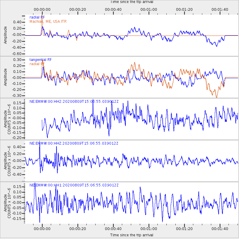
Signal To Noise
| Channel | StoN | STA | LTA |
| NE:EMMW:00:HHZ:20200809T15:06:55.039012Z | 1.6578943 | 1.2326389E-7 | 7.4349664E-8 |
| NE:EMMW:00:HH1:20200809T15:06:55.039012Z | 1.9736061 | 6.684505E-8 | 3.3869497E-8 |
| NE:EMMW:00:HH2:20200809T15:06:55.039012Z | 0.9931471 | 5.2586483E-8 | 5.2949343E-8 |
| Arrivals |
| Ps | |
| PpPs | |
| PsPs/PpSs | |


