You are here: Home > Network List > US - United States National Seismic Network Stations List
> Station AMTX Amarillo, Texas, USA > Earthquake Result Viewer
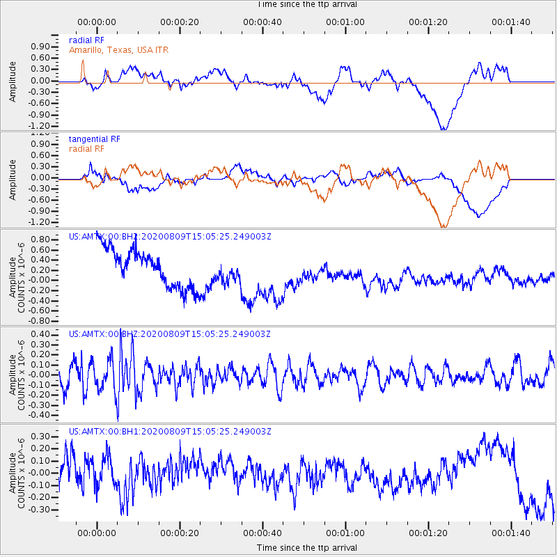
AMTX Amarillo, Texas, USA - Earthquake Result Viewer
*The percent match for this event was below the threshold and hence no stack was calculated.
| Earthquake location: |
Alaska Peninsula |
| Earthquake latitude/longitude: |
55.5/-158.1 |
| Earthquake time(UTC): |
2020/08/09 (222) 14:57:52 GMT |
| Earthquake Depth: |
0.0 km |
| Earthquake Magnitude: |
5.6 ml |
| Earthquake Catalog/Contributor: |
NEIC PDE/ak |
|
| Network: |
US United States National Seismic Network |
| Station: |
AMTX Amarillo, Texas, USA |
| Lat/Lon: |
34.53 N/101.41 W |
| Elevation: |
1010 m |
|
| Distance: |
43.8 deg |
| Az: |
94.307 deg |
| Baz: |
316.559 deg |
| Ray Param: |
$rayparam |
*The percent match for this event was below the threshold and hence was not used in the summary stack. |
|
| Radial Match: |
20.959703 % |
| Radial Bump: |
400 |
| Transverse Match: |
24.396156 % |
| Transverse Bump: |
400 |
| SOD ConfigId: |
21709731 |
| Insert Time: |
2020-08-23 15:35:24.142 +0000 |
| GWidth: |
2.5 |
| Max Bumps: |
400 |
| Tol: |
0.001 |
|
Signal To Noise
| Channel | StoN | STA | LTA |
| US:AMTX:00:BHZ:20200809T15:05:25.249003Z | 1.5544446 | 1.5471201E-7 | 9.9528805E-8 |
| US:AMTX:00:BH1:20200809T15:05:25.249003Z | 1.1072879 | 1.4875266E-7 | 1.3433964E-7 |
| US:AMTX:00:BH2:20200809T15:05:25.249003Z | 1.2376083 | 4.134392E-7 | 3.3406306E-7 |
| Arrivals |
| Ps | |
| PpPs | |
| PsPs/PpSs | |


