You are here: Home > Network List > AV - Alaska Volcano Observatory Stations List
> Station AMKA Regional Station, Amchitka Island, Alaska > Earthquake Result Viewer
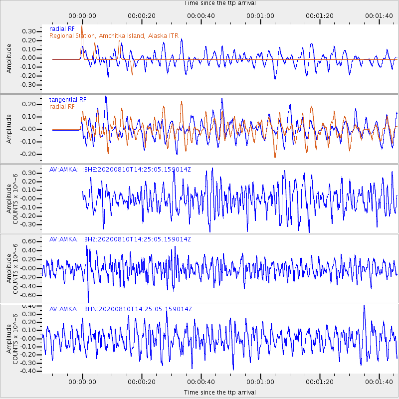
AMKA Regional Station, Amchitka Island, Alaska - Earthquake Result Viewer
*The percent match for this event was below the threshold and hence no stack was calculated.
| Earthquake location: |
North Of Honduras |
| Earthquake latitude/longitude: |
16.9/-85.9 |
| Earthquake time(UTC): |
2020/08/10 (223) 14:13:27 GMT |
| Earthquake Depth: |
10 km |
| Earthquake Magnitude: |
5.7 Mww |
| Earthquake Catalog/Contributor: |
NEIC PDE/us |
|
| Network: |
AV Alaska Volcano Observatory |
| Station: |
AMKA Regional Station, Amchitka Island, Alaska |
| Lat/Lon: |
51.38 N/179.30 E |
| Elevation: |
116 m |
|
| Distance: |
80.0 deg |
| Az: |
320.64 deg |
| Baz: |
75.674 deg |
| Ray Param: |
$rayparam |
*The percent match for this event was below the threshold and hence was not used in the summary stack. |
|
| Radial Match: |
50.786827 % |
| Radial Bump: |
400 |
| Transverse Match: |
49.802536 % |
| Transverse Bump: |
400 |
| SOD ConfigId: |
21709731 |
| Insert Time: |
2020-08-24 14:16:21.558 +0000 |
| GWidth: |
2.5 |
| Max Bumps: |
400 |
| Tol: |
0.001 |
|
Signal To Noise
| Channel | StoN | STA | LTA |
| AV:AMKA: :BHZ:20200810T14:25:05.159014Z | 2.0876117 | 2.684064E-7 | 1.2857103E-7 |
| AV:AMKA: :BHN:20200810T14:25:05.159014Z | 1.2400175 | 1.2488174E-7 | 1.00709656E-7 |
| AV:AMKA: :BHE:20200810T14:25:05.159014Z | 1.4480762 | 1.5164134E-7 | 1.0471918E-7 |
| Arrivals |
| Ps | |
| PpPs | |
| PsPs/PpSs | |


