You are here: Home > Network List > AZ - ANZA Regional Network Stations List
> Station SMER AZ.SMER > Earthquake Result Viewer
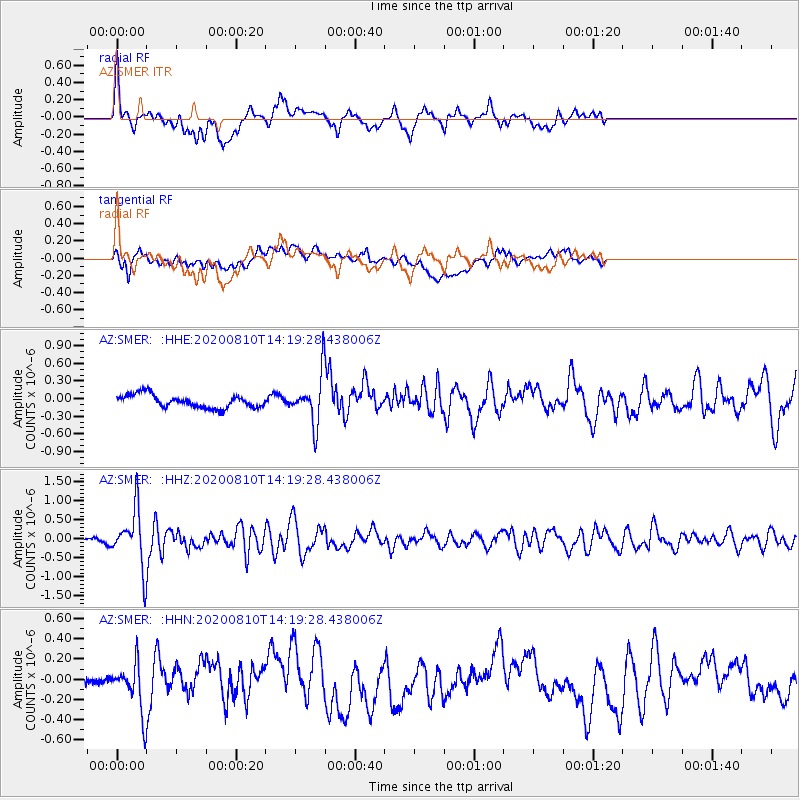
SMER AZ.SMER - Earthquake Result Viewer
*The percent match for this event was below the threshold and hence no stack was calculated.
| Earthquake location: |
North Of Honduras |
| Earthquake latitude/longitude: |
16.9/-85.9 |
| Earthquake time(UTC): |
2020/08/10 (223) 14:13:27 GMT |
| Earthquake Depth: |
10 km |
| Earthquake Magnitude: |
5.7 Mww |
| Earthquake Catalog/Contributor: |
NEIC PDE/us |
|
| Network: |
AZ ANZA Regional Network |
| Station: |
SMER AZ.SMER |
| Lat/Lon: |
33.46 N/117.17 W |
| Elevation: |
355 m |
|
| Distance: |
32.6 deg |
| Az: |
306.328 deg |
| Baz: |
112.668 deg |
| Ray Param: |
$rayparam |
*The percent match for this event was below the threshold and hence was not used in the summary stack. |
|
| Radial Match: |
73.77131 % |
| Radial Bump: |
400 |
| Transverse Match: |
54.158737 % |
| Transverse Bump: |
400 |
| SOD ConfigId: |
21709731 |
| Insert Time: |
2020-08-24 14:17:23.813 +0000 |
| GWidth: |
2.5 |
| Max Bumps: |
400 |
| Tol: |
0.001 |
|
Signal To Noise
| Channel | StoN | STA | LTA |
| AZ:SMER: :HHZ:20200810T14:19:28.438006Z | 6.9346266 | 7.2424007E-7 | 1.0443823E-7 |
| AZ:SMER: :HHN:20200810T14:19:28.438006Z | 1.8199914 | 2.2728871E-7 | 1.2488451E-7 |
| AZ:SMER: :HHE:20200810T14:19:28.438006Z | 3.7225134 | 4.059254E-7 | 1.0904605E-7 |
| Arrivals |
| Ps | |
| PpPs | |
| PsPs/PpSs | |


