You are here: Home > Network List > CI - Caltech Regional Seismic Network Stations List
> Station MUR Murrieta > Earthquake Result Viewer
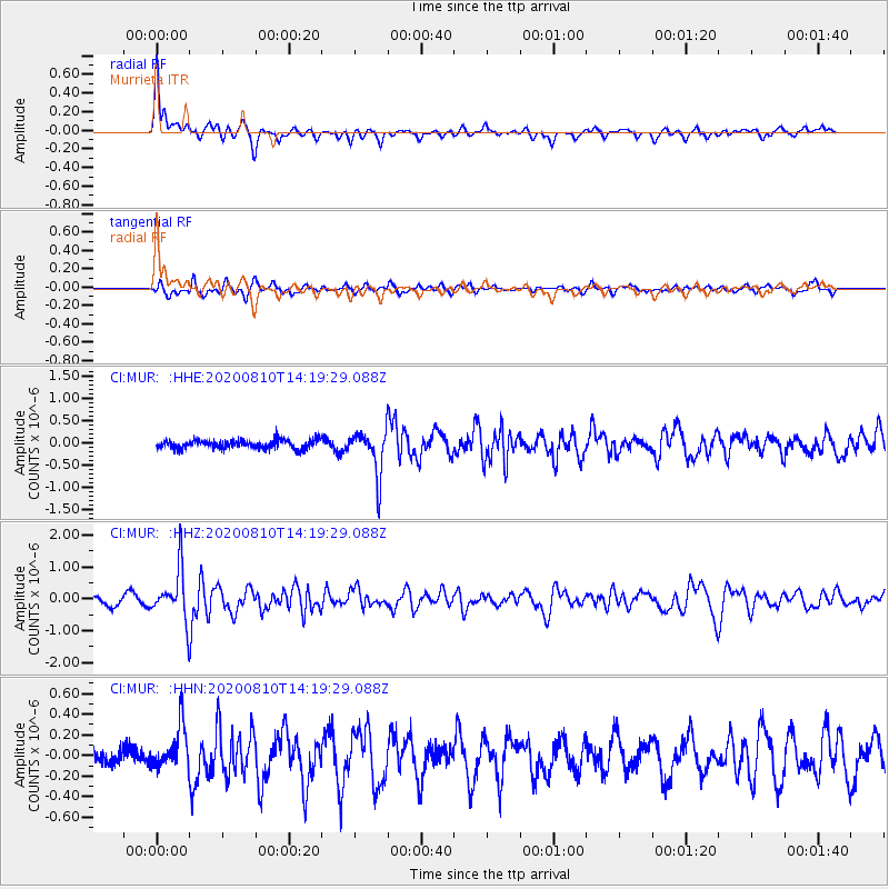
MUR Murrieta - Earthquake Result Viewer
*The percent match for this event was below the threshold and hence no stack was calculated.
| Earthquake location: |
North Of Honduras |
| Earthquake latitude/longitude: |
16.9/-85.9 |
| Earthquake time(UTC): |
2020/08/10 (223) 14:13:27 GMT |
| Earthquake Depth: |
10 km |
| Earthquake Magnitude: |
5.7 Mww |
| Earthquake Catalog/Contributor: |
NEIC PDE/us |
|
| Network: |
CI Caltech Regional Seismic Network |
| Station: |
MUR Murrieta |
| Lat/Lon: |
33.60 N/117.20 W |
| Elevation: |
562 m |
|
| Distance: |
32.7 deg |
| Az: |
306.555 deg |
| Baz: |
112.846 deg |
| Ray Param: |
$rayparam |
*The percent match for this event was below the threshold and hence was not used in the summary stack. |
|
| Radial Match: |
74.93027 % |
| Radial Bump: |
370 |
| Transverse Match: |
65.03865 % |
| Transverse Bump: |
390 |
| SOD ConfigId: |
21709731 |
| Insert Time: |
2020-08-24 14:20:48.283 +0000 |
| GWidth: |
2.5 |
| Max Bumps: |
400 |
| Tol: |
0.001 |
|
Signal To Noise
| Channel | StoN | STA | LTA |
| CI:MUR: :HHZ:20200810T14:19:29.088Z | 7.7543225 | 7.852996E-7 | 1.012725E-7 |
| CI:MUR: :HHN:20200810T14:19:29.088Z | 1.9495645 | 2.0855254E-7 | 1.06973914E-7 |
| CI:MUR: :HHE:20200810T14:19:29.088Z | 5.091813 | 4.9994E-7 | 9.818506E-8 |
| Arrivals |
| Ps | |
| PpPs | |
| PsPs/PpSs | |


