You are here: Home > Network List > CI - Caltech Regional Seismic Network Stations List
> Station SWS Sam W. Stewart, Westmorland, CA, USA > Earthquake Result Viewer
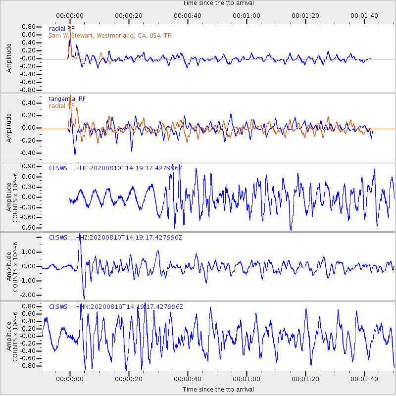
SWS Sam W. Stewart, Westmorland, CA, USA - Earthquake Result Viewer
*The percent match for this event was below the threshold and hence no stack was calculated.
| Earthquake location: |
North Of Honduras |
| Earthquake latitude/longitude: |
16.9/-85.9 |
| Earthquake time(UTC): |
2020/08/10 (223) 14:13:27 GMT |
| Earthquake Depth: |
10 km |
| Earthquake Magnitude: |
5.7 Mww |
| Earthquake Catalog/Contributor: |
NEIC PDE/us |
|
| Network: |
CI Caltech Regional Seismic Network |
| Station: |
SWS Sam W. Stewart, Westmorland, CA, USA |
| Lat/Lon: |
32.94 N/115.80 W |
| Elevation: |
140 m |
|
| Distance: |
31.4 deg |
| Az: |
306.283 deg |
| Baz: |
113.38 deg |
| Ray Param: |
$rayparam |
*The percent match for this event was below the threshold and hence was not used in the summary stack. |
|
| Radial Match: |
75.83738 % |
| Radial Bump: |
400 |
| Transverse Match: |
67.12476 % |
| Transverse Bump: |
400 |
| SOD ConfigId: |
21709731 |
| Insert Time: |
2020-08-24 14:21:17.359 +0000 |
| GWidth: |
2.5 |
| Max Bumps: |
400 |
| Tol: |
0.001 |
|
Signal To Noise
| Channel | StoN | STA | LTA |
| CI:SWS: :HHZ:20200810T14:19:17.427996Z | 7.999807 | 9.216556E-7 | 1.1520973E-7 |
| CI:SWS: :HHN:20200810T14:19:17.427996Z | 1.271513 | 2.8427905E-7 | 2.2357544E-7 |
| CI:SWS: :HHE:20200810T14:19:17.427996Z | 2.6350555 | 4.341141E-7 | 1.6474571E-7 |
| Arrivals |
| Ps | |
| PpPs | |
| PsPs/PpSs | |


