You are here: Home > Network List > CI - Caltech Regional Seismic Network Stations List
> Station TIN Tinemaha, Big Pine, CA, USA > Earthquake Result Viewer
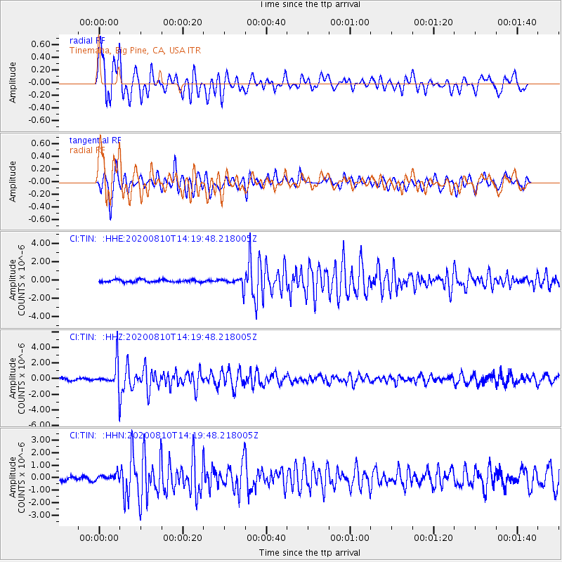
TIN Tinemaha, Big Pine, CA, USA - Earthquake Result Viewer
*The percent match for this event was below the threshold and hence no stack was calculated.
| Earthquake location: |
North Of Honduras |
| Earthquake latitude/longitude: |
16.9/-85.9 |
| Earthquake time(UTC): |
2020/08/10 (223) 14:13:27 GMT |
| Earthquake Depth: |
10 km |
| Earthquake Magnitude: |
5.7 Mww |
| Earthquake Catalog/Contributor: |
NEIC PDE/us |
|
| Network: |
CI Caltech Regional Seismic Network |
| Station: |
TIN Tinemaha, Big Pine, CA, USA |
| Lat/Lon: |
37.05 N/118.23 W |
| Elevation: |
1197 m |
|
| Distance: |
34.9 deg |
| Az: |
311.553 deg |
| Baz: |
116.405 deg |
| Ray Param: |
$rayparam |
*The percent match for this event was below the threshold and hence was not used in the summary stack. |
|
| Radial Match: |
79.755 % |
| Radial Bump: |
400 |
| Transverse Match: |
77.03548 % |
| Transverse Bump: |
400 |
| SOD ConfigId: |
21709731 |
| Insert Time: |
2020-08-24 14:21:20.983 +0000 |
| GWidth: |
2.5 |
| Max Bumps: |
400 |
| Tol: |
0.001 |
|
Signal To Noise
| Channel | StoN | STA | LTA |
| CI:TIN: :HHZ:20200810T14:19:48.218005Z | 10.678964 | 1.7016603E-6 | 1.5934695E-7 |
| CI:TIN: :HHN:20200810T14:19:48.218005Z | 1.2873741 | 2.5631263E-7 | 1.9909723E-7 |
| CI:TIN: :HHE:20200810T14:19:48.218005Z | 4.6031938 | 6.0450213E-7 | 1.3132232E-7 |
| Arrivals |
| Ps | |
| PpPs | |
| PsPs/PpSs | |


