You are here: Home > Network List > HV - Hawaiian Volcano Observatory Network Stations List
> Station MLOD Mauna Loa, Hawaii Digital > Earthquake Result Viewer
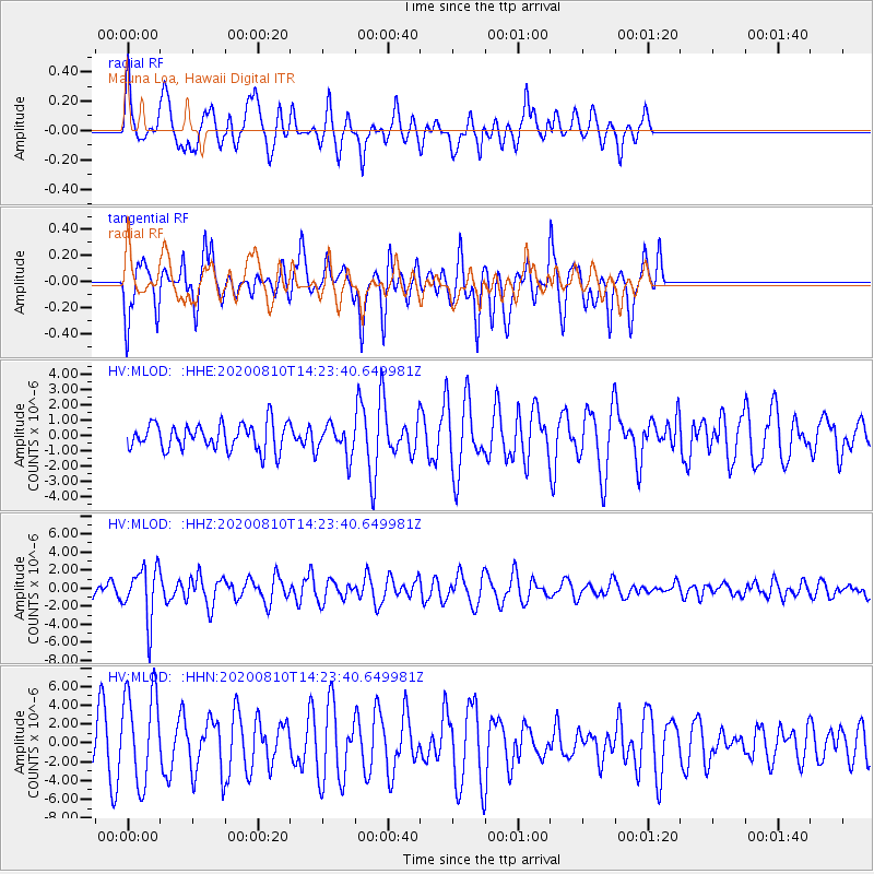
MLOD Mauna Loa, Hawaii Digital - Earthquake Result Viewer
*The percent match for this event was below the threshold and hence no stack was calculated.
| Earthquake location: |
North Of Honduras |
| Earthquake latitude/longitude: |
16.9/-85.9 |
| Earthquake time(UTC): |
2020/08/10 (223) 14:13:27 GMT |
| Earthquake Depth: |
10 km |
| Earthquake Magnitude: |
5.7 Mww |
| Earthquake Catalog/Contributor: |
NEIC PDE/us |
|
| Network: |
HV Hawaiian Volcano Observatory Network |
| Station: |
MLOD Mauna Loa, Hawaii Digital |
| Lat/Lon: |
19.49 N/155.39 W |
| Elevation: |
2044 m |
|
| Distance: |
65.7 deg |
| Az: |
284.128 deg |
| Baz: |
79.827 deg |
| Ray Param: |
$rayparam |
*The percent match for this event was below the threshold and hence was not used in the summary stack. |
|
| Radial Match: |
69.069496 % |
| Radial Bump: |
358 |
| Transverse Match: |
43.871887 % |
| Transverse Bump: |
321 |
| SOD ConfigId: |
21709731 |
| Insert Time: |
2020-08-24 14:24:50.808 +0000 |
| GWidth: |
2.5 |
| Max Bumps: |
400 |
| Tol: |
0.001 |
|
Signal To Noise
| Channel | StoN | STA | LTA |
| HV:MLOD: :HHZ:20200810T14:23:40.649981Z | 2.944736 | 2.8890177E-6 | 9.810786E-7 |
| HV:MLOD: :HHN:20200810T14:23:40.649981Z | 2.8007152 | 4.92889E-6 | 1.7598684E-6 |
| HV:MLOD: :HHE:20200810T14:23:40.649981Z | 1.197856 | 1.0280464E-6 | 8.582388E-7 |
| Arrivals |
| Ps | |
| PpPs | |
| PsPs/PpSs | |


