You are here: Home > Network List > NE - New England Seismic Network Stations List
> Station EMMW Machias, ME, USA > Earthquake Result Viewer
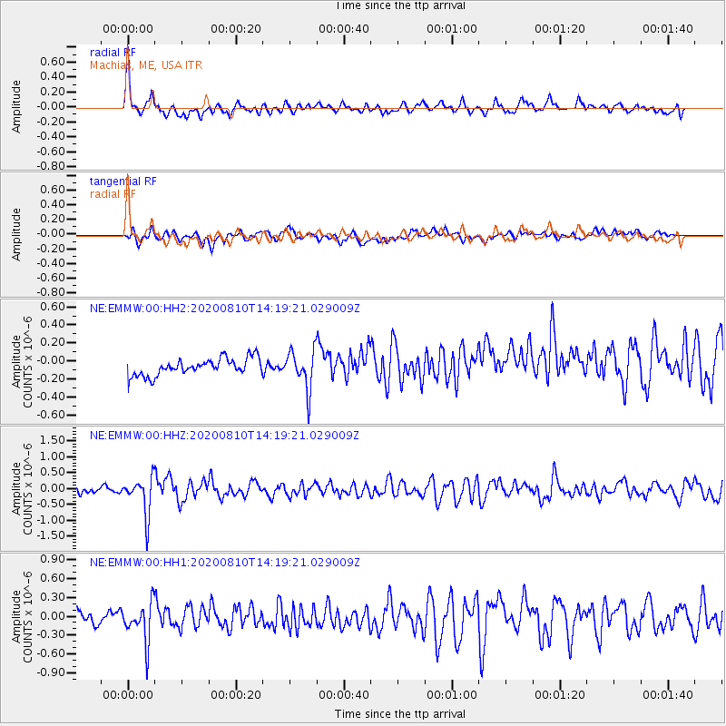
EMMW Machias, ME, USA - Earthquake Result Viewer
*The percent match for this event was below the threshold and hence no stack was calculated.
| Earthquake location: |
North Of Honduras |
| Earthquake latitude/longitude: |
16.9/-85.9 |
| Earthquake time(UTC): |
2020/08/10 (223) 14:13:27 GMT |
| Earthquake Depth: |
10 km |
| Earthquake Magnitude: |
5.7 Mww |
| Earthquake Catalog/Contributor: |
NEIC PDE/us |
|
| Network: |
NE New England Seismic Network |
| Station: |
EMMW Machias, ME, USA |
| Lat/Lon: |
44.71 N/67.46 W |
| Elevation: |
35 m |
|
| Distance: |
31.8 deg |
| Az: |
25.304 deg |
| Baz: |
215.025 deg |
| Ray Param: |
$rayparam |
*The percent match for this event was below the threshold and hence was not used in the summary stack. |
|
| Radial Match: |
70.873604 % |
| Radial Bump: |
400 |
| Transverse Match: |
49.89292 % |
| Transverse Bump: |
400 |
| SOD ConfigId: |
21709731 |
| Insert Time: |
2020-08-24 14:26:14.498 +0000 |
| GWidth: |
2.5 |
| Max Bumps: |
400 |
| Tol: |
0.001 |
|
Signal To Noise
| Channel | StoN | STA | LTA |
| NE:EMMW:00:HHZ:20200810T14:19:21.029009Z | 6.501662 | 5.983213E-7 | 9.202591E-8 |
| NE:EMMW:00:HH1:20200810T14:19:21.029009Z | 3.0226302 | 3.2063056E-7 | 1.0607668E-7 |
| NE:EMMW:00:HH2:20200810T14:19:21.029009Z | 2.3180513 | 2.1734289E-7 | 9.376103E-8 |
| Arrivals |
| Ps | |
| PpPs | |
| PsPs/PpSs | |


