You are here: Home > Network List > TA - USArray Transportable Network (new EarthScope stations) Stations List
> Station E20K Nigu River, AK, USA > Earthquake Result Viewer
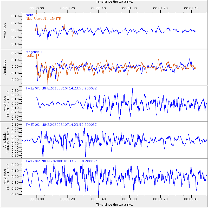
E20K Nigu River, AK, USA - Earthquake Result Viewer
*The percent match for this event was below the threshold and hence no stack was calculated.
| Earthquake location: |
North Of Honduras |
| Earthquake latitude/longitude: |
16.9/-85.9 |
| Earthquake time(UTC): |
2020/08/10 (223) 14:13:27 GMT |
| Earthquake Depth: |
10 km |
| Earthquake Magnitude: |
5.7 Mww |
| Earthquake Catalog/Contributor: |
NEIC PDE/us |
|
| Network: |
TA USArray Transportable Network (new EarthScope stations) |
| Station: |
E20K Nigu River, AK, USA |
| Lat/Lon: |
68.26 N/156.19 W |
| Elevation: |
866 m |
|
| Distance: |
67.2 deg |
| Az: |
337.628 deg |
| Baz: |
102.002 deg |
| Ray Param: |
$rayparam |
*The percent match for this event was below the threshold and hence was not used in the summary stack. |
|
| Radial Match: |
78.60128 % |
| Radial Bump: |
400 |
| Transverse Match: |
56.928616 % |
| Transverse Bump: |
400 |
| SOD ConfigId: |
21709731 |
| Insert Time: |
2020-08-24 14:29:05.607 +0000 |
| GWidth: |
2.5 |
| Max Bumps: |
400 |
| Tol: |
0.001 |
|
Signal To Noise
| Channel | StoN | STA | LTA |
| TA:E20K: :BHZ:20200810T14:23:50.20003Z | 3.0547402 | 3.179463E-7 | 1.0408293E-7 |
| TA:E20K: :BHN:20200810T14:23:50.20003Z | 1.1331838 | 1.0976755E-7 | 9.686649E-8 |
| TA:E20K: :BHE:20200810T14:23:50.20003Z | 2.2635663 | 9.14765E-8 | 4.041256E-8 |
| Arrivals |
| Ps | |
| PpPs | |
| PsPs/PpSs | |


