You are here: Home > Network List > TA - USArray Transportable Network (new EarthScope stations) Stations List
> Station H16K Elim, AK, USA > Earthquake Result Viewer
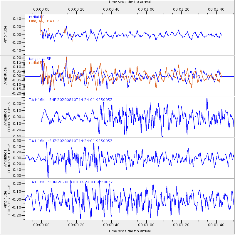
H16K Elim, AK, USA - Earthquake Result Viewer
*The percent match for this event was below the threshold and hence no stack was calculated.
| Earthquake location: |
North Of Honduras |
| Earthquake latitude/longitude: |
16.9/-85.9 |
| Earthquake time(UTC): |
2020/08/10 (223) 14:13:27 GMT |
| Earthquake Depth: |
10 km |
| Earthquake Magnitude: |
5.7 Mww |
| Earthquake Catalog/Contributor: |
NEIC PDE/us |
|
| Network: |
TA USArray Transportable Network (new EarthScope stations) |
| Station: |
H16K Elim, AK, USA |
| Lat/Lon: |
64.64 N/162.24 W |
| Elevation: |
216 m |
|
| Distance: |
69.1 deg |
| Az: |
333.373 deg |
| Baz: |
94.872 deg |
| Ray Param: |
$rayparam |
*The percent match for this event was below the threshold and hence was not used in the summary stack. |
|
| Radial Match: |
63.36796 % |
| Radial Bump: |
400 |
| Transverse Match: |
55.210083 % |
| Transverse Bump: |
400 |
| SOD ConfigId: |
21709731 |
| Insert Time: |
2020-08-24 14:29:39.280 +0000 |
| GWidth: |
2.5 |
| Max Bumps: |
400 |
| Tol: |
0.001 |
|
Signal To Noise
| Channel | StoN | STA | LTA |
| TA:H16K: :BHZ:20200810T14:24:01.925005Z | 3.0413747 | 2.5542522E-7 | 8.398348E-8 |
| TA:H16K: :BHN:20200810T14:24:01.925005Z | 1.6837456 | 8.9123525E-8 | 5.2931703E-8 |
| TA:H16K: :BHE:20200810T14:24:01.925005Z | 2.1089327 | 1.0676633E-7 | 5.0625765E-8 |
| Arrivals |
| Ps | |
| PpPs | |
| PsPs/PpSs | |


