You are here: Home > Network List > TA - USArray Transportable Network (new EarthScope stations) Stations List
> Station I17K Unalakleet, AK, USA > Earthquake Result Viewer
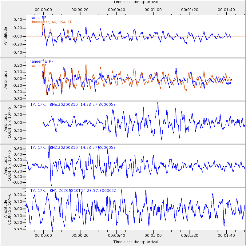
I17K Unalakleet, AK, USA - Earthquake Result Viewer
*The percent match for this event was below the threshold and hence no stack was calculated.
| Earthquake location: |
North Of Honduras |
| Earthquake latitude/longitude: |
16.9/-85.9 |
| Earthquake time(UTC): |
2020/08/10 (223) 14:13:27 GMT |
| Earthquake Depth: |
10 km |
| Earthquake Magnitude: |
5.7 Mww |
| Earthquake Catalog/Contributor: |
NEIC PDE/us |
|
| Network: |
TA USArray Transportable Network (new EarthScope stations) |
| Station: |
I17K Unalakleet, AK, USA |
| Lat/Lon: |
63.89 N/160.70 W |
| Elevation: |
105 m |
|
| Distance: |
68.3 deg |
| Az: |
332.635 deg |
| Baz: |
95.993 deg |
| Ray Param: |
$rayparam |
*The percent match for this event was below the threshold and hence was not used in the summary stack. |
|
| Radial Match: |
59.58589 % |
| Radial Bump: |
400 |
| Transverse Match: |
43.46303 % |
| Transverse Bump: |
400 |
| SOD ConfigId: |
21709731 |
| Insert Time: |
2020-08-24 14:29:47.930 +0000 |
| GWidth: |
2.5 |
| Max Bumps: |
400 |
| Tol: |
0.001 |
|
Signal To Noise
| Channel | StoN | STA | LTA |
| TA:I17K: :BHZ:20200810T14:23:57.300005Z | 3.6568022 | 3.3603305E-7 | 9.18926E-8 |
| TA:I17K: :BHN:20200810T14:23:57.300005Z | 1.8166939 | 1.4287257E-7 | 7.864427E-8 |
| TA:I17K: :BHE:20200810T14:23:57.300005Z | 1.2541118 | 9.487472E-8 | 7.565093E-8 |
| Arrivals |
| Ps | |
| PpPs | |
| PsPs/PpSs | |


