You are here: Home > Network List > TA - USArray Transportable Network (new EarthScope stations) Stations List
> Station K13K Kusilvak Mountain, AK, USA > Earthquake Result Viewer
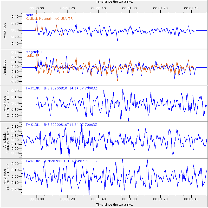
K13K Kusilvak Mountain, AK, USA - Earthquake Result Viewer
*The percent match for this event was below the threshold and hence no stack was calculated.
| Earthquake location: |
North Of Honduras |
| Earthquake latitude/longitude: |
16.9/-85.9 |
| Earthquake time(UTC): |
2020/08/10 (223) 14:13:27 GMT |
| Earthquake Depth: |
10 km |
| Earthquake Magnitude: |
5.7 Mww |
| Earthquake Catalog/Contributor: |
NEIC PDE/us |
|
| Network: |
TA USArray Transportable Network (new EarthScope stations) |
| Station: |
K13K Kusilvak Mountain, AK, USA |
| Lat/Lon: |
61.93 N/164.66 W |
| Elevation: |
204 m |
|
| Distance: |
70.0 deg |
| Az: |
330.413 deg |
| Baz: |
91.68 deg |
| Ray Param: |
$rayparam |
*The percent match for this event was below the threshold and hence was not used in the summary stack. |
|
| Radial Match: |
42.543785 % |
| Radial Bump: |
400 |
| Transverse Match: |
43.216793 % |
| Transverse Bump: |
400 |
| SOD ConfigId: |
21709731 |
| Insert Time: |
2020-08-24 14:29:55.366 +0000 |
| GWidth: |
2.5 |
| Max Bumps: |
400 |
| Tol: |
0.001 |
|
Signal To Noise
| Channel | StoN | STA | LTA |
| TA:K13K: :BHZ:20200810T14:24:07.70003Z | 1.7662808 | 1.12431835E-7 | 6.365456E-8 |
| TA:K13K: :BHN:20200810T14:24:07.70003Z | 1.1065732 | 8.8040025E-8 | 7.9560955E-8 |
| TA:K13K: :BHE:20200810T14:24:07.70003Z | 2.4643283 | 1.4228216E-7 | 5.7736692E-8 |
| Arrivals |
| Ps | |
| PpPs | |
| PsPs/PpSs | |


