You are here: Home > Network List > AU - Australian Seismological Centre Stations List
> Station FORT Forrest, Western Australia > Earthquake Result Viewer
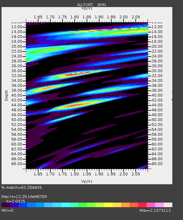
FORT Forrest, Western Australia - Earthquake Result Viewer
| Earthquake location: |
Mindanao, Philippines |
| Earthquake latitude/longitude: |
6.2/126.9 |
| Earthquake time(UTC): |
2008/03/20 (080) 14:10:44 GMT |
| Earthquake Depth: |
82 km |
| Earthquake Magnitude: |
6.0 MB, 6.1 MW, 6.1 MW |
| Earthquake Catalog/Contributor: |
WHDF/NEIC |
|
| Network: |
AU Australian Seismological Centre |
| Station: |
FORT Forrest, Western Australia |
| Lat/Lon: |
30.78 S/128.06 E |
| Elevation: |
165 m |
|
| Distance: |
36.8 deg |
| Az: |
178.376 deg |
| Baz: |
358.124 deg |
| Ray Param: |
0.07625186 |
| Estimated Moho Depth: |
12.25 km |
| Estimated Crust Vp/Vs: |
2.04 |
| Assumed Crust Vp: |
6.479 km/s |
| Estimated Crust Vs: |
3.172 km/s |
| Estimated Crust Poisson's Ratio: |
0.34 |
|
| Radial Match: |
83.256645 % |
| Radial Bump: |
400 |
| Transverse Match: |
65.683304 % |
| Transverse Bump: |
400 |
| SOD ConfigId: |
2564 |
| Insert Time: |
2010-03-08 23:56:38.324 +0000 |
| GWidth: |
2.5 |
| Max Bumps: |
400 |
| Tol: |
0.001 |
|

Signal To Noise
| Channel | StoN | STA | LTA |
| AU:FORT: :BHN:20080320T14:17:13.783013Z | 3.2520807 | 1.6626005E-6 | 5.112421E-7 |
| AU:FORT: :BHE:20080320T14:17:13.783013Z | 0.96846724 | 5.9612984E-7 | 6.1553953E-7 |
| AU:FORT: :BHZ:20080320T14:17:13.783013Z | 3.971884 | 2.3043856E-6 | 5.8017446E-7 |
| Arrivals |
| Ps | 2.1 SECOND |
| PpPs | 5.4 SECOND |
| PsPs/PpSs | 7.5 SECOND |


