You are here: Home > Network List > UU - University of Utah Regional Network Stations List
> Station LIUT Lila Canyon, UT, USA > Earthquake Result Viewer
LIUT Lila Canyon, UT, USA - Earthquake Result Viewer
| Earthquake location: |
North Of Honduras |
| Earthquake latitude/longitude: |
16.9/-85.9 |
| Earthquake time(UTC): |
2020/08/10 (223) 14:13:27 GMT |
| Earthquake Depth: |
10 km |
| Earthquake Magnitude: |
5.7 Mww |
| Earthquake Catalog/Contributor: |
NEIC PDE/us |
|
| Network: |
UU University of Utah Regional Network |
| Station: |
LIUT Lila Canyon, UT, USA |
| Lat/Lon: |
39.42 N/110.33 W |
| Elevation: |
2178 m |
|
| Distance: |
31.0 deg |
| Az: |
321.435 deg |
| Baz: |
129.588 deg |
| Ray Param: |
0.07924936 |
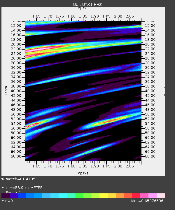
| Estimated Moho Depth: |
55.0 km |
| Estimated Crust Vp/Vs: |
1.62 |
| Assumed Crust Vp: |
6.207 km/s |
| Estimated Crust Vs: |
3.843 km/s |
| Estimated Crust Poisson's Ratio: |
0.19 |
|
| Radial Match: |
81.41053 % |
| Radial Bump: |
400 |
| Transverse Match: |
59.769566 % |
| Transverse Bump: |
400 |
| SOD ConfigId: |
21709731 |
| Insert Time: |
2020-08-24 14:31:47.439 +0000 |
| GWidth: |
2.5 |
| Max Bumps: |
400 |
| Tol: |
0.001 |
|

Signal To Noise
| Channel | StoN | STA | LTA |
| UU:LIUT:01:HHZ:20200810T14:19:13.840014Z | 4.101155 | 1.1876469E-8 | 2.8958842E-9 |
| UU:LIUT:01:HHN:20200810T14:19:13.840014Z | 1.49707 | 6.6637535E-9 | 4.451197E-9 |
| UU:LIUT:01:HHE:20200810T14:19:13.840014Z | 1.2247415 | 4.2091224E-9 | 3.4367436E-9 |
| Arrivals |
| Ps | 5.9 SECOND |
| PpPs | 21 SECOND |
| PsPs/PpSs | 27 SECOND |


