You are here: Home > Network List > AU - Australian Seismological Centre Stations List
> Station FORT Forrest, Western Australia > Earthquake Result Viewer
FORT Forrest, Western Australia - Earthquake Result Viewer
| Earthquake location: |
Philippine Islands Region |
| Earthquake latitude/longitude: |
19.9/121.3 |
| Earthquake time(UTC): |
2008/03/03 (063) 13:49:40 GMT |
| Earthquake Depth: |
10 km |
| Earthquake Magnitude: |
6.0 MB, 6.0 MW, 5.9 MW |
| Earthquake Catalog/Contributor: |
WHDF/NEIC |
|
| Network: |
AU Australian Seismological Centre |
| Station: |
FORT Forrest, Western Australia |
| Lat/Lon: |
30.78 S/128.06 E |
| Elevation: |
165 m |
|
| Distance: |
50.8 deg |
| Az: |
172.529 deg |
| Baz: |
351.827 deg |
| Ray Param: |
0.0678042 |
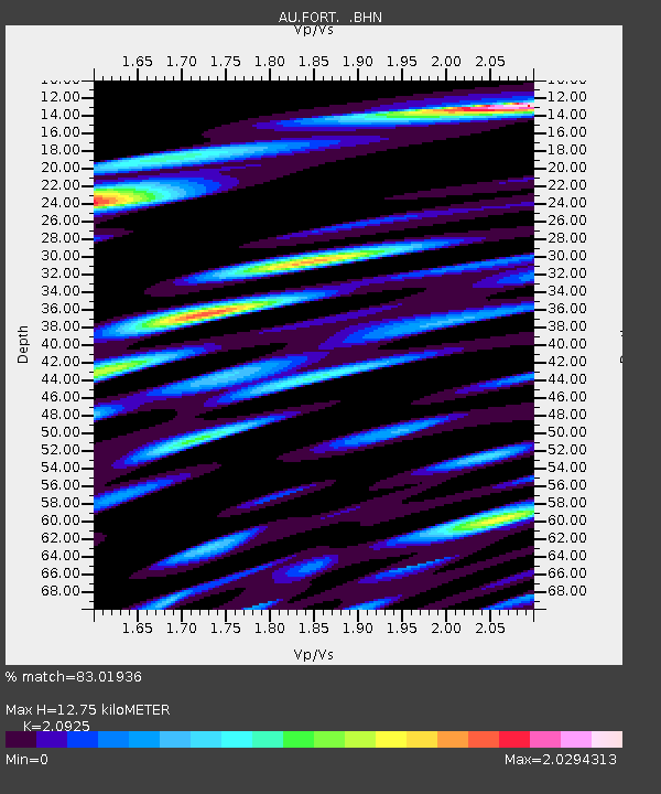
| Estimated Moho Depth: |
12.75 km |
| Estimated Crust Vp/Vs: |
2.09 |
| Assumed Crust Vp: |
6.479 km/s |
| Estimated Crust Vs: |
3.096 km/s |
| Estimated Crust Poisson's Ratio: |
0.35 |
|
| Radial Match: |
83.01936 % |
| Radial Bump: |
400 |
| Transverse Match: |
74.24758 % |
| Transverse Bump: |
400 |
| SOD ConfigId: |
2564 |
| Insert Time: |
2010-03-08 23:56:42.709 +0000 |
| GWidth: |
2.5 |
| Max Bumps: |
400 |
| Tol: |
0.001 |
|

Signal To Noise
| Channel | StoN | STA | LTA |
| AU:FORT: :BHN:20080303T13:58:09.985002Z | 5.4263434 | 4.018902E-6 | 7.4062797E-7 |
| AU:FORT: :BHE:20080303T13:58:09.985002Z | 2.2395709 | 1.1301273E-6 | 5.046178E-7 |
| AU:FORT: :BHZ:20080303T13:58:09.985002Z | 6.647987 | 3.9894635E-6 | 6.00101E-7 |
| Arrivals |
| Ps | 2.3 SECOND |
| PpPs | 5.8 SECOND |
| PsPs/PpSs | 8.1 SECOND |


