You are here: Home > Network List > CA - Catalan Seismic Network Stations List
> Station CFON Fontmartina > Earthquake Result Viewer
CFON Fontmartina - Earthquake Result Viewer
| Earthquake location: |
Tanzania |
| Earthquake latitude/longitude: |
-7.3/39.8 |
| Earthquake time(UTC): |
2020/08/12 (225) 17:13:15 GMT |
| Earthquake Depth: |
12 km |
| Earthquake Magnitude: |
5.9 mww |
| Earthquake Catalog/Contributor: |
NEIC PDE/us |
|
| Network: |
CA Catalan Seismic Network |
| Station: |
CFON Fontmartina |
| Lat/Lon: |
41.76 N/2.43 E |
| Elevation: |
973 m |
|
| Distance: |
59.6 deg |
| Az: |
328.237 deg |
| Baz: |
135.738 deg |
| Ray Param: |
0.062059637 |
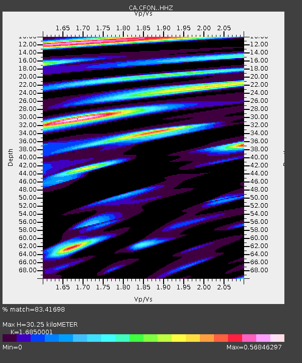
| Estimated Moho Depth: |
30.25 km |
| Estimated Crust Vp/Vs: |
1.69 |
| Assumed Crust Vp: |
5.88 km/s |
| Estimated Crust Vs: |
3.49 km/s |
| Estimated Crust Poisson's Ratio: |
0.23 |
|
| Radial Match: |
83.41698 % |
| Radial Bump: |
400 |
| Transverse Match: |
78.365746 % |
| Transverse Bump: |
400 |
| SOD ConfigId: |
21709731 |
| Insert Time: |
2020-08-26 17:14:41.950 +0000 |
| GWidth: |
2.5 |
| Max Bumps: |
400 |
| Tol: |
0.001 |
|
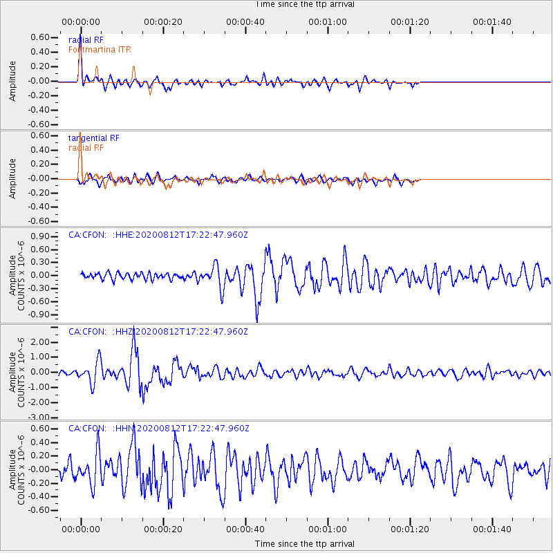
Signal To Noise
| Channel | StoN | STA | LTA |
| CA:CFON: :HHZ:20200812T17:22:47.960Z | 4.5029435 | 7.415561E-7 | 1.6468253E-7 |
| CA:CFON: :HHN:20200812T17:22:47.960Z | 2.5095153 | 2.380051E-7 | 9.484106E-8 |
| CA:CFON: :HHE:20200812T17:22:47.960Z | 3.7898371 | 2.6044745E-7 | 6.87226E-8 |
| Arrivals |
| Ps | 3.7 SECOND |
| PpPs | 13 SECOND |
| PsPs/PpSs | 17 SECOND |


