You are here: Home > Network List > AU - Australian Seismological Centre Stations List
> Station FORT Forrest, Western Australia > Earthquake Result Viewer
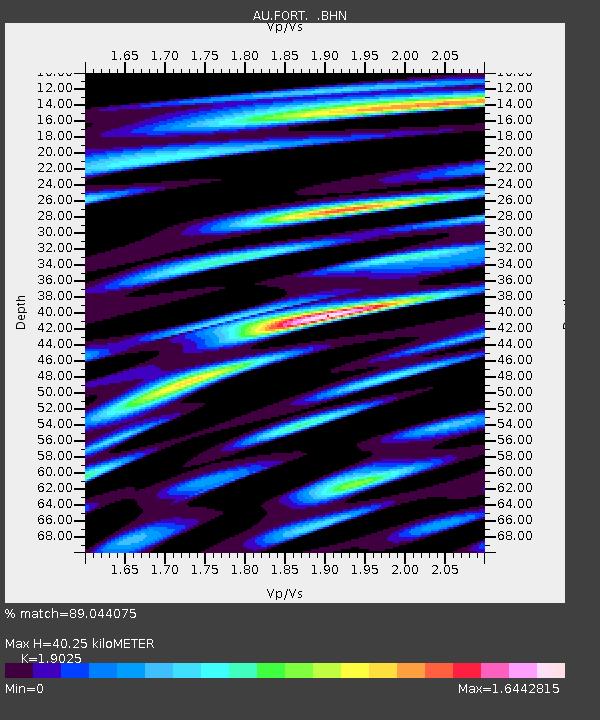
FORT Forrest, Western Australia - Earthquake Result Viewer
| Earthquake location: |
Vanuatu Islands |
| Earthquake latitude/longitude: |
-17.8/167.9 |
| Earthquake time(UTC): |
2009/06/02 (153) 02:17:03 GMT |
| Earthquake Depth: |
15 km |
| Earthquake Magnitude: |
5.7 MB, 6.2 MS, 6.3 MW, 6.3 MW |
| Earthquake Catalog/Contributor: |
WHDF/NEIC |
|
| Network: |
AU Australian Seismological Centre |
| Station: |
FORT Forrest, Western Australia |
| Lat/Lon: |
30.78 S/128.06 E |
| Elevation: |
165 m |
|
| Distance: |
38.4 deg |
| Az: |
242.685 deg |
| Baz: |
79.667 deg |
| Ray Param: |
0.075568214 |
| Estimated Moho Depth: |
40.25 km |
| Estimated Crust Vp/Vs: |
1.90 |
| Assumed Crust Vp: |
6.479 km/s |
| Estimated Crust Vs: |
3.406 km/s |
| Estimated Crust Poisson's Ratio: |
0.31 |
|
| Radial Match: |
89.044075 % |
| Radial Bump: |
400 |
| Transverse Match: |
64.03986 % |
| Transverse Bump: |
400 |
| SOD ConfigId: |
2648 |
| Insert Time: |
2010-03-08 23:57:26.782 +0000 |
| GWidth: |
2.5 |
| Max Bumps: |
400 |
| Tol: |
0.001 |
|

Signal To Noise
| Channel | StoN | STA | LTA |
| AU:FORT: :BHN:20090602T02:23:53.400015Z | 5.175848 | 1.0080231E-6 | 1.9475517E-7 |
| AU:FORT: :BHE:20090602T02:23:53.400015Z | 1.1039082 | 4.4088193E-7 | 3.9938277E-7 |
| AU:FORT: :BHZ:20090602T02:23:53.400015Z | 3.8315458 | 9.381756E-7 | 2.4485564E-7 |
| Arrivals |
| Ps | 6.0 SECOND |
| PpPs | 17 SECOND |
| PsPs/PpSs | 23 SECOND |


