You are here: Home > Network List > MN - MEDNET Project Stations List
> Station VSL Villasalto, Italy > Earthquake Result Viewer
VSL Villasalto, Italy - Earthquake Result Viewer
| Earthquake location: |
Tanzania |
| Earthquake latitude/longitude: |
-7.3/39.8 |
| Earthquake time(UTC): |
2020/08/12 (225) 17:13:15 GMT |
| Earthquake Depth: |
12 km |
| Earthquake Magnitude: |
5.9 mww |
| Earthquake Catalog/Contributor: |
NEIC PDE/us |
|
| Network: |
MN MEDNET Project |
| Station: |
VSL Villasalto, Italy |
| Lat/Lon: |
39.50 N/9.38 E |
| Elevation: |
370 m |
|
| Distance: |
54.4 deg |
| Az: |
331.201 deg |
| Baz: |
141.861 deg |
| Ray Param: |
0.065448046 |
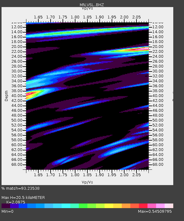
| Estimated Moho Depth: |
20.5 km |
| Estimated Crust Vp/Vs: |
2.10 |
| Assumed Crust Vp: |
6.183 km/s |
| Estimated Crust Vs: |
2.948 km/s |
| Estimated Crust Poisson's Ratio: |
0.35 |
|
| Radial Match: |
93.23538 % |
| Radial Bump: |
400 |
| Transverse Match: |
80.21585 % |
| Transverse Bump: |
400 |
| SOD ConfigId: |
21709731 |
| Insert Time: |
2020-08-26 17:19:11.325 +0000 |
| GWidth: |
2.5 |
| Max Bumps: |
400 |
| Tol: |
0.001 |
|

Signal To Noise
| Channel | StoN | STA | LTA |
| MN:VSL: :BHZ:20200812T17:22:11.368997Z | 7.237954 | 5.24055E-7 | 7.240375E-8 |
| MN:VSL: :BHN:20200812T17:22:11.368997Z | 3.8061857 | 1.9474388E-7 | 5.1165102E-8 |
| MN:VSL: :BHE:20200812T17:22:11.368997Z | 4.6471877 | 1.2668713E-7 | 2.7261029E-8 |
| Arrivals |
| Ps | 3.8 SECOND |
| PpPs | 9.9 SECOND |
| PsPs/PpSs | 14 SECOND |


