You are here: Home > Network List > PM - Portuguese National Seismic Network Stations List
> Station PFVI PM.PFVI > Earthquake Result Viewer
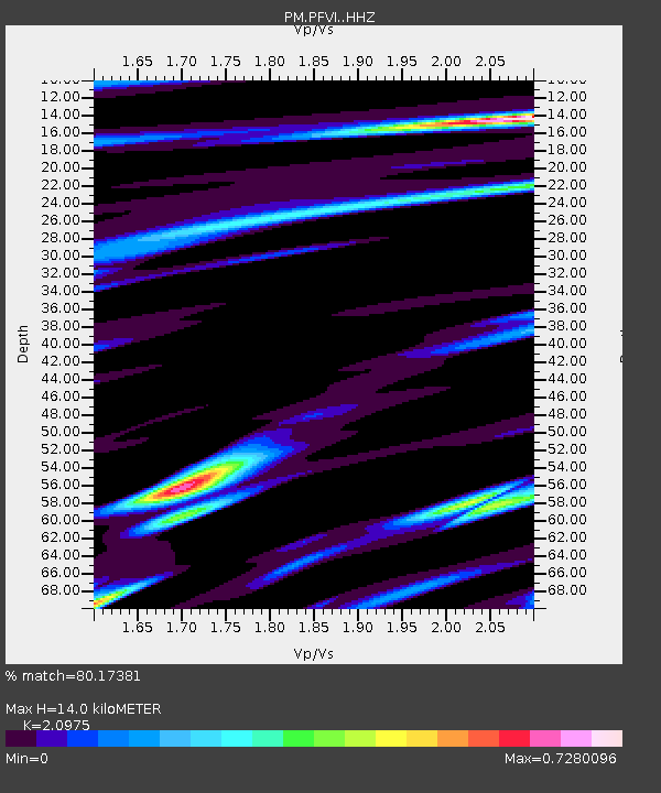
PFVI PM.PFVI - Earthquake Result Viewer
| Earthquake location: |
Tanzania |
| Earthquake latitude/longitude: |
-7.3/39.8 |
| Earthquake time(UTC): |
2020/08/12 (225) 17:13:15 GMT |
| Earthquake Depth: |
12 km |
| Earthquake Magnitude: |
5.9 mww |
| Earthquake Catalog/Contributor: |
NEIC PDE/us |
|
| Network: |
PM Portuguese National Seismic Network |
| Station: |
PFVI PM.PFVI |
| Lat/Lon: |
37.13 N/8.83 W |
| Elevation: |
189 m |
|
| Distance: |
63.4 deg |
| Az: |
317.872 deg |
| Baz: |
123.636 deg |
| Ray Param: |
0.05959843 |
| Estimated Moho Depth: |
14.0 km |
| Estimated Crust Vp/Vs: |
2.10 |
| Assumed Crust Vp: |
6.048 km/s |
| Estimated Crust Vs: |
2.883 km/s |
| Estimated Crust Poisson's Ratio: |
0.35 |
|
| Radial Match: |
80.17381 % |
| Radial Bump: |
400 |
| Transverse Match: |
66.01905 % |
| Transverse Bump: |
400 |
| SOD ConfigId: |
21709731 |
| Insert Time: |
2020-08-26 17:19:58.018 +0000 |
| GWidth: |
2.5 |
| Max Bumps: |
400 |
| Tol: |
0.001 |
|

Signal To Noise
| Channel | StoN | STA | LTA |
| PM:PFVI: :HHZ:20200812T17:23:13.429971Z | 3.758801 | 6.1980467E-7 | 1.6489426E-7 |
| PM:PFVI: :HHN:20200812T17:23:13.429971Z | 1.5863956 | 1.7139853E-7 | 1.0804274E-7 |
| PM:PFVI: :HHE:20200812T17:23:13.429971Z | 2.0962641 | 2.6080218E-7 | 1.2441285E-7 |
| Arrivals |
| Ps | 2.6 SECOND |
| PpPs | 6.9 SECOND |
| PsPs/PpSs | 9.6 SECOND |


