You are here: Home > Network List > TJ - Tajikistan National Seismic Network Stations List
> Station GARM Garm, Tajikistan > Earthquake Result Viewer
GARM Garm, Tajikistan - Earthquake Result Viewer
| Earthquake location: |
Tanzania |
| Earthquake latitude/longitude: |
-7.3/39.8 |
| Earthquake time(UTC): |
2020/08/12 (225) 17:13:15 GMT |
| Earthquake Depth: |
12 km |
| Earthquake Magnitude: |
5.9 mww |
| Earthquake Catalog/Contributor: |
NEIC PDE/us |
|
| Network: |
TJ Tajikistan National Seismic Network |
| Station: |
GARM Garm, Tajikistan |
| Lat/Lon: |
39.00 N/70.32 E |
| Elevation: |
1305 m |
|
| Distance: |
54.1 deg |
| Az: |
29.232 deg |
| Baz: |
218.438 deg |
| Ray Param: |
0.06566653 |
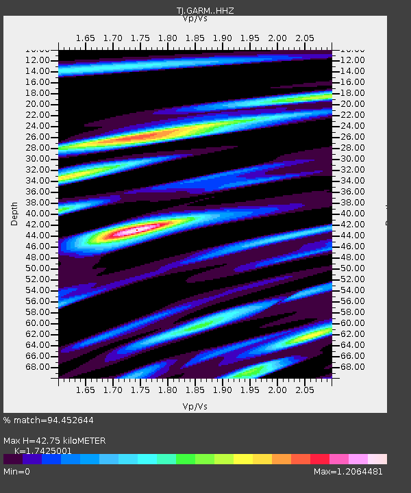
| Estimated Moho Depth: |
42.75 km |
| Estimated Crust Vp/Vs: |
1.74 |
| Assumed Crust Vp: |
6.306 km/s |
| Estimated Crust Vs: |
3.619 km/s |
| Estimated Crust Poisson's Ratio: |
0.25 |
|
| Radial Match: |
94.452644 % |
| Radial Bump: |
400 |
| Transverse Match: |
90.173546 % |
| Transverse Bump: |
400 |
| SOD ConfigId: |
21709731 |
| Insert Time: |
2020-08-26 17:20:29.445 +0000 |
| GWidth: |
2.5 |
| Max Bumps: |
400 |
| Tol: |
0.001 |
|
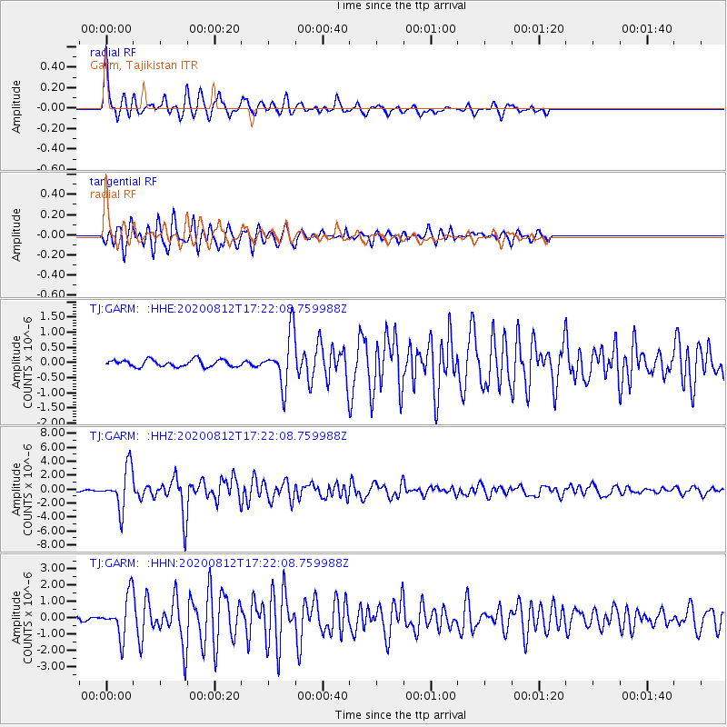
Signal To Noise
| Channel | StoN | STA | LTA |
| TJ:GARM: :HHZ:20200812T17:22:08.759988Z | 23.134995 | 2.9368223E-6 | 1.2694285E-7 |
| TJ:GARM: :HHN:20200812T17:22:08.759988Z | 13.320914 | 1.2423121E-6 | 9.3260276E-8 |
| TJ:GARM: :HHE:20200812T17:22:08.759988Z | 7.483674 | 8.553363E-7 | 1.14293634E-7 |
| Arrivals |
| Ps | 5.3 SECOND |
| PpPs | 18 SECOND |
| PsPs/PpSs | 23 SECOND |


