You are here: Home > Network List > AU - Australian Seismological Centre Stations List
> Station FORT Forrest, Western Australia > Earthquake Result Viewer
FORT Forrest, Western Australia - Earthquake Result Viewer
| Earthquake location: |
New Britain Region, P.N.G. |
| Earthquake latitude/longitude: |
-5.7/149.5 |
| Earthquake time(UTC): |
2009/05/12 (132) 01:26:26 GMT |
| Earthquake Depth: |
84 km |
| Earthquake Magnitude: |
5.9 MB, 6.1 MW, 6.1 MW |
| Earthquake Catalog/Contributor: |
WHDF/NEIC |
|
| Network: |
AU Australian Seismological Centre |
| Station: |
FORT Forrest, Western Australia |
| Lat/Lon: |
30.78 S/128.06 E |
| Elevation: |
165 m |
|
| Distance: |
32.1 deg |
| Az: |
216.345 deg |
| Baz: |
43.259 deg |
| Ray Param: |
0.07857214 |
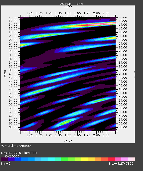
| Estimated Moho Depth: |
13.25 km |
| Estimated Crust Vp/Vs: |
2.05 |
| Assumed Crust Vp: |
6.479 km/s |
| Estimated Crust Vs: |
3.157 km/s |
| Estimated Crust Poisson's Ratio: |
0.34 |
|
| Radial Match: |
87.68989 % |
| Radial Bump: |
400 |
| Transverse Match: |
67.52416 % |
| Transverse Bump: |
400 |
| SOD ConfigId: |
2760 |
| Insert Time: |
2010-03-08 23:57:48.758 +0000 |
| GWidth: |
2.5 |
| Max Bumps: |
400 |
| Tol: |
0.001 |
|

Signal To Noise
| Channel | StoN | STA | LTA |
| AU:FORT: :BHN:20090512T01:32:15.250002Z | 6.147675 | 1.806734E-6 | 2.9388897E-7 |
| AU:FORT: :BHE:20090512T01:32:15.250002Z | 4.868429 | 1.753058E-6 | 3.60087E-7 |
| AU:FORT: :BHZ:20090512T01:32:15.250002Z | 4.6749005 | 1.6080141E-6 | 3.4396754E-7 |
| Arrivals |
| Ps | 2.3 SECOND |
| PpPs | 5.8 SECOND |
| PsPs/PpSs | 8.1 SECOND |


