You are here: Home > Network List > IW - Intermountain West Stations List
> Station PLID Pearl Lake, Idaho, USA > Earthquake Result Viewer
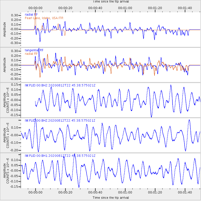
PLID Pearl Lake, Idaho, USA - Earthquake Result Viewer
*The percent match for this event was below the threshold and hence no stack was calculated.
| Earthquake location: |
Philippine Islands Region |
| Earthquake latitude/longitude: |
19.9/121.3 |
| Earthquake time(UTC): |
2020/08/12 (225) 22:32:38 GMT |
| Earthquake Depth: |
10 km |
| Earthquake Magnitude: |
5.5 Mww |
| Earthquake Catalog/Contributor: |
NEIC PDE/us |
|
| Network: |
IW Intermountain West |
| Station: |
PLID Pearl Lake, Idaho, USA |
| Lat/Lon: |
45.09 N/116.00 W |
| Elevation: |
2164 m |
|
| Distance: |
97.0 deg |
| Az: |
36.895 deg |
| Baz: |
307.125 deg |
| Ray Param: |
$rayparam |
*The percent match for this event was below the threshold and hence was not used in the summary stack. |
|
| Radial Match: |
54.07898 % |
| Radial Bump: |
400 |
| Transverse Match: |
59.075047 % |
| Transverse Bump: |
400 |
| SOD ConfigId: |
21709731 |
| Insert Time: |
2020-08-26 22:40:26.520 +0000 |
| GWidth: |
2.5 |
| Max Bumps: |
400 |
| Tol: |
0.001 |
|
Signal To Noise
| Channel | StoN | STA | LTA |
| IW:PLID:00:BHZ:20200812T22:45:38.575021Z | 2.8302517 | 1.3480427E-7 | 4.7629783E-8 |
| IW:PLID:00:BH1:20200812T22:45:38.575021Z | 1.2717327 | 7.3340466E-8 | 5.766972E-8 |
| IW:PLID:00:BH2:20200812T22:45:38.575021Z | 0.4894537 | 2.8262832E-8 | 5.7743627E-8 |
| Arrivals |
| Ps | |
| PpPs | |
| PsPs/PpSs | |


