You are here: Home > Network List > TA - USArray Transportable Network (new EarthScope stations) Stations List
> Station F20K Avaraart Lake, AK, USA > Earthquake Result Viewer
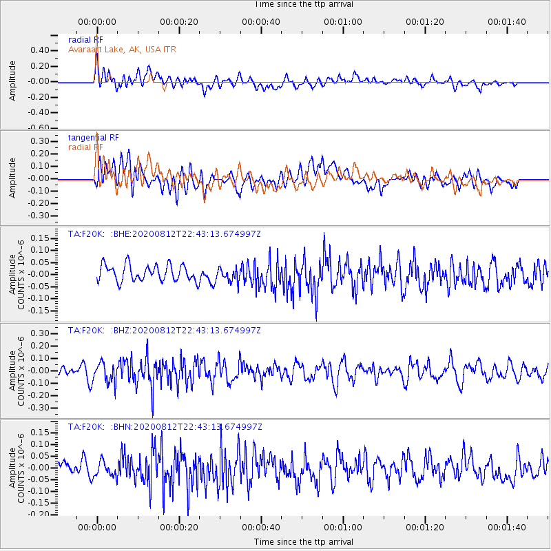
F20K Avaraart Lake, AK, USA - Earthquake Result Viewer
*The percent match for this event was below the threshold and hence no stack was calculated.
| Earthquake location: |
Philippine Islands Region |
| Earthquake latitude/longitude: |
19.9/121.3 |
| Earthquake time(UTC): |
2020/08/12 (225) 22:32:38 GMT |
| Earthquake Depth: |
10 km |
| Earthquake Magnitude: |
5.5 Mww |
| Earthquake Catalog/Contributor: |
NEIC PDE/us |
|
| Network: |
TA USArray Transportable Network (new EarthScope stations) |
| Station: |
F20K Avaraart Lake, AK, USA |
| Lat/Lon: |
67.05 N/155.73 W |
| Elevation: |
136 m |
|
| Distance: |
69.1 deg |
| Az: |
24.624 deg |
| Baz: |
271.688 deg |
| Ray Param: |
$rayparam |
*The percent match for this event was below the threshold and hence was not used in the summary stack. |
|
| Radial Match: |
56.218475 % |
| Radial Bump: |
400 |
| Transverse Match: |
49.200607 % |
| Transverse Bump: |
400 |
| SOD ConfigId: |
21709731 |
| Insert Time: |
2020-08-26 22:43:08.150 +0000 |
| GWidth: |
2.5 |
| Max Bumps: |
400 |
| Tol: |
0.001 |
|
Signal To Noise
| Channel | StoN | STA | LTA |
| TA:F20K: :BHZ:20200812T22:43:13.674997Z | 2.1139128 | 7.8071295E-8 | 3.6932125E-8 |
| TA:F20K: :BHN:20200812T22:43:13.674997Z | 1.0575311 | 3.1265245E-8 | 2.956437E-8 |
| TA:F20K: :BHE:20200812T22:43:13.674997Z | 0.84969056 | 2.8407339E-8 | 3.343257E-8 |
| Arrivals |
| Ps | |
| PpPs | |
| PsPs/PpSs | |


