You are here: Home > Network List > CI - Caltech Regional Seismic Network Stations List
> Station DGR Domenigoni Reservoir, California, USA > Earthquake Result Viewer
DGR Domenigoni Reservoir, California, USA - Earthquake Result Viewer
*The percent match for this event was below the threshold and hence no stack was calculated.
| Earthquake location: |
Unimak Island Region, Alaska |
| Earthquake latitude/longitude: |
53.4/-163.7 |
| Earthquake time(UTC): |
2020/08/13 (226) 06:39:58 GMT |
| Earthquake Depth: |
10 km |
| Earthquake Magnitude: |
5.7 mww |
| Earthquake Catalog/Contributor: |
NEIC PDE/us |
|
| Network: |
CI Caltech Regional Seismic Network |
| Station: |
DGR Domenigoni Reservoir, California, USA |
| Lat/Lon: |
33.65 N/117.01 W |
| Elevation: |
609 m |
|
| Distance: |
38.3 deg |
| Az: |
101.934 deg |
| Baz: |
315.411 deg |
| Ray Param: |
$rayparam |
*The percent match for this event was below the threshold and hence was not used in the summary stack. |
|
| Radial Match: |
55.82312 % |
| Radial Bump: |
400 |
| Transverse Match: |
72.62661 % |
| Transverse Bump: |
366 |
| SOD ConfigId: |
21709731 |
| Insert Time: |
2020-08-27 06:42:48.933 +0000 |
| GWidth: |
2.5 |
| Max Bumps: |
400 |
| Tol: |
0.001 |
|
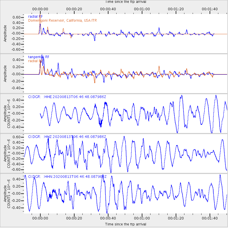
Signal To Noise
| Channel | StoN | STA | LTA |
| CI:DGR: :HHZ:20200813T06:46:48.087986Z | 1.2053435 | 2.3981133E-7 | 1.9895685E-7 |
| CI:DGR: :HHN:20200813T06:46:48.087986Z | 1.0564176 | 2.4411256E-7 | 2.310758E-7 |
| CI:DGR: :HHE:20200813T06:46:48.087986Z | 0.92127943 | 1.4936991E-7 | 1.6213312E-7 |
| Arrivals |
| Ps | |
| PpPs | |
| PsPs/PpSs | |


