You are here: Home > Network List > UW - Pacific Northwest Regional Seismic Network Stations List
> Station IRON Crane, OR, USA > Earthquake Result Viewer
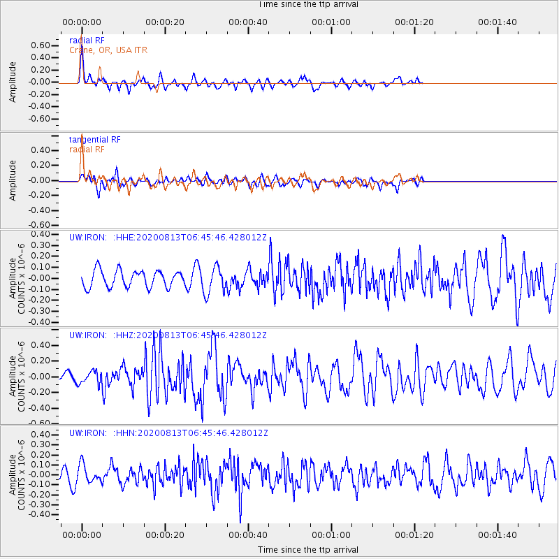
IRON Crane, OR, USA - Earthquake Result Viewer
*The percent match for this event was below the threshold and hence no stack was calculated.
| Earthquake location: |
Unimak Island Region, Alaska |
| Earthquake latitude/longitude: |
53.4/-163.7 |
| Earthquake time(UTC): |
2020/08/13 (226) 06:39:58 GMT |
| Earthquake Depth: |
10 km |
| Earthquake Magnitude: |
5.7 mww |
| Earthquake Catalog/Contributor: |
NEIC PDE/us |
|
| Network: |
UW Pacific Northwest Regional Seismic Network |
| Station: |
IRON Crane, OR, USA |
| Lat/Lon: |
43.36 N/118.47 W |
| Elevation: |
1226 m |
|
| Distance: |
31.2 deg |
| Az: |
90.232 deg |
| Baz: |
304.856 deg |
| Ray Param: |
$rayparam |
*The percent match for this event was below the threshold and hence was not used in the summary stack. |
|
| Radial Match: |
71.10366 % |
| Radial Bump: |
366 |
| Transverse Match: |
66.80213 % |
| Transverse Bump: |
400 |
| SOD ConfigId: |
21709731 |
| Insert Time: |
2020-08-27 07:00:45.994 +0000 |
| GWidth: |
2.5 |
| Max Bumps: |
400 |
| Tol: |
0.001 |
|
Signal To Noise
| Channel | StoN | STA | LTA |
| UW:IRON: :HHZ:20200813T06:45:46.428012Z | 0.7388236 | 7.974699E-8 | 1.07937794E-7 |
| UW:IRON: :HHN:20200813T06:45:46.428012Z | 1.5329226 | 8.9931426E-8 | 5.8666643E-8 |
| UW:IRON: :HHE:20200813T06:45:46.428012Z | 1.6106678 | 1.2166211E-7 | 7.55352E-8 |
| Arrivals |
| Ps | |
| PpPs | |
| PsPs/PpSs | |


