You are here: Home > Network List > AU - Australian Seismological Centre Stations List
> Station KMBL Kambalda, Western Australia > Earthquake Result Viewer
KMBL Kambalda, Western Australia - Earthquake Result Viewer
| Earthquake location: |
Macquarie Island Region |
| Earthquake latitude/longitude: |
-55.7/158.5 |
| Earthquake time(UTC): |
2008/04/12 (103) 00:30:12 GMT |
| Earthquake Depth: |
16 km |
| Earthquake Magnitude: |
6.8 MB, 7.1 MS, 7.1 MW, 7.1 MW |
| Earthquake Catalog/Contributor: |
WHDF/NEIC |
|
| Network: |
AU Australian Seismological Centre |
| Station: |
KMBL Kambalda, Western Australia |
| Lat/Lon: |
31.37 S/121.88 E |
| Elevation: |
370 m |
|
| Distance: |
35.3 deg |
| Az: |
298.138 deg |
| Baz: |
144.259 deg |
| Ray Param: |
0.077277966 |
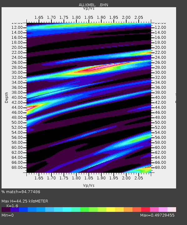
| Estimated Moho Depth: |
44.25 km |
| Estimated Crust Vp/Vs: |
1.60 |
| Assumed Crust Vp: |
6.459 km/s |
| Estimated Crust Vs: |
4.037 km/s |
| Estimated Crust Poisson's Ratio: |
0.18 |
|
| Radial Match: |
94.77486 % |
| Radial Bump: |
316 |
| Transverse Match: |
77.672295 % |
| Transverse Bump: |
400 |
| SOD ConfigId: |
2504 |
| Insert Time: |
2010-03-09 00:01:33.431 +0000 |
| GWidth: |
2.5 |
| Max Bumps: |
400 |
| Tol: |
0.001 |
|

Signal To Noise
| Channel | StoN | STA | LTA |
| AU:KMBL: :BHN:20080412T00:36:36.050012Z | 23.162323 | 9.0489075E-6 | 3.9067356E-7 |
| AU:KMBL: :BHE:20080412T00:36:36.050012Z | 19.78137 | 4.331892E-6 | 2.1898848E-7 |
| AU:KMBL: :BHZ:20080412T00:36:36.050012Z | 14.618038 | 3.7295158E-6 | 2.5513108E-7 |
| Arrivals |
| Ps | 4.5 SECOND |
| PpPs | 16 SECOND |
| PsPs/PpSs | 21 SECOND |


