You are here: Home > Network List > AU - Australian Seismological Centre Stations List
> Station KMBL Kambalda, Western Australia > Earthquake Result Viewer
KMBL Kambalda, Western Australia - Earthquake Result Viewer
| Earthquake location: |
Solomon Islands |
| Earthquake latitude/longitude: |
-10.5/161.3 |
| Earthquake time(UTC): |
2008/06/03 (155) 16:20:50 GMT |
| Earthquake Depth: |
84 km |
| Earthquake Magnitude: |
6.2 MB, 6.2 MW, 6.2 MW |
| Earthquake Catalog/Contributor: |
WHDF/NEIC |
|
| Network: |
AU Australian Seismological Centre |
| Station: |
KMBL Kambalda, Western Australia |
| Lat/Lon: |
31.37 S/121.88 E |
| Elevation: |
370 m |
|
| Distance: |
41.9 deg |
| Az: |
234.333 deg |
| Baz: |
69.072 deg |
| Ray Param: |
0.07321277 |
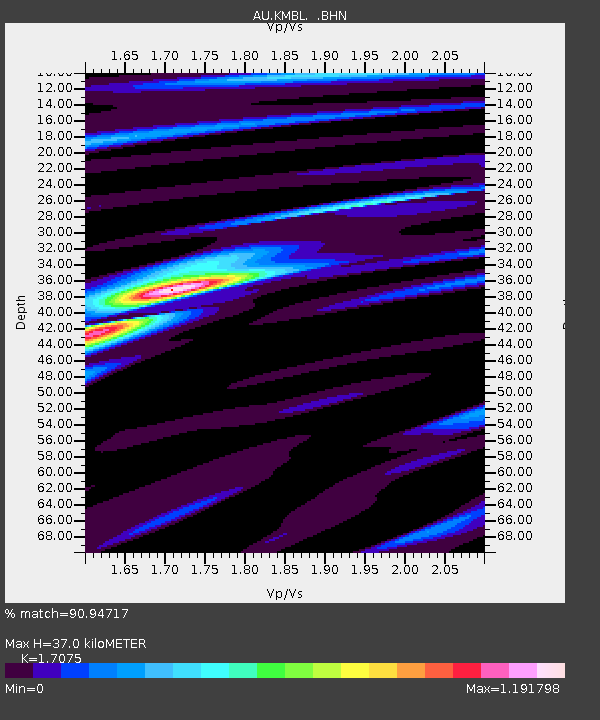
| Estimated Moho Depth: |
37.0 km |
| Estimated Crust Vp/Vs: |
1.71 |
| Assumed Crust Vp: |
6.459 km/s |
| Estimated Crust Vs: |
3.783 km/s |
| Estimated Crust Poisson's Ratio: |
0.24 |
|
| Radial Match: |
90.94717 % |
| Radial Bump: |
263 |
| Transverse Match: |
67.90668 % |
| Transverse Bump: |
400 |
| SOD ConfigId: |
2504 |
| Insert Time: |
2010-03-09 00:01:41.483 +0000 |
| GWidth: |
2.5 |
| Max Bumps: |
400 |
| Tol: |
0.001 |
|

Signal To Noise
| Channel | StoN | STA | LTA |
| AU:KMBL: :BHN:20080603T16:28:02.350001Z | 14.131915 | 4.2303027E-6 | 2.9934392E-7 |
| AU:KMBL: :BHE:20080603T16:28:02.350001Z | 3.6075237 | 1.0480678E-6 | 2.905228E-7 |
| AU:KMBL: :BHZ:20080603T16:28:02.350001Z | 8.150253 | 2.287437E-6 | 2.806584E-7 |
| Arrivals |
| Ps | 4.4 SECOND |
| PpPs | 14 SECOND |
| PsPs/PpSs | 19 SECOND |


