You are here: Home > Network List > ET - CERI Southern Appalachian seismic Network Stations List
> Station SWET Sewanee,TN > Earthquake Result Viewer
SWET Sewanee,TN - Earthquake Result Viewer
| Earthquake location: |
Easter Island Region |
| Earthquake latitude/longitude: |
-22.7/-112.3 |
| Earthquake time(UTC): |
2020/08/15 (228) 06:40:38 GMT |
| Earthquake Depth: |
10 km |
| Earthquake Magnitude: |
5.7 mww |
| Earthquake Catalog/Contributor: |
NEIC PDE/us |
|
| Network: |
ET CERI Southern Appalachian seismic Network |
| Station: |
SWET Sewanee,TN |
| Lat/Lon: |
35.22 N/85.93 W |
| Elevation: |
581 m |
|
| Distance: |
62.8 deg |
| Az: |
24.148 deg |
| Baz: |
207.479 deg |
| Ray Param: |
0.05999331 |
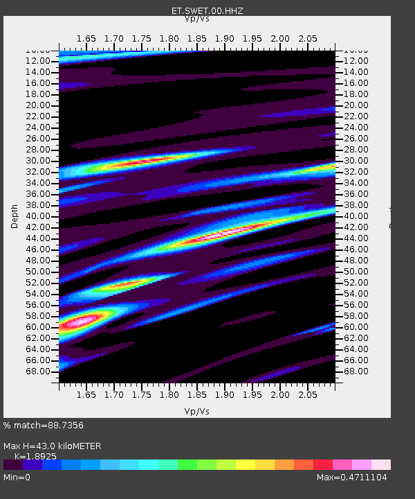
| Estimated Moho Depth: |
43.0 km |
| Estimated Crust Vp/Vs: |
1.89 |
| Assumed Crust Vp: |
6.35 km/s |
| Estimated Crust Vs: |
3.355 km/s |
| Estimated Crust Poisson's Ratio: |
0.31 |
|
| Radial Match: |
88.7356 % |
| Radial Bump: |
337 |
| Transverse Match: |
71.94147 % |
| Transverse Bump: |
400 |
| SOD ConfigId: |
21709731 |
| Insert Time: |
2020-08-29 06:57:13.363 +0000 |
| GWidth: |
2.5 |
| Max Bumps: |
400 |
| Tol: |
0.001 |
|

Signal To Noise
| Channel | StoN | STA | LTA |
| ET:SWET:00:HHZ:20200815T06:50:32.500Z | 11.923996 | 7.0755715E-7 | 5.9338927E-8 |
| ET:SWET:00:HHN:20200815T06:50:32.500Z | 4.3469195 | 2.6486987E-7 | 6.093277E-8 |
| ET:SWET:00:HHE:20200815T06:50:32.500Z | 4.3675995 | 1.795617E-7 | 4.1112216E-8 |
| Arrivals |
| Ps | 6.3 SECOND |
| PpPs | 19 SECOND |
| PsPs/PpSs | 25 SECOND |


