You are here: Home > Network List > UU - University of Utah Regional Network Stations List
> Station FOR3 Blundell North, UT, USA > Earthquake Result Viewer
FOR3 Blundell North, UT, USA - Earthquake Result Viewer
| Earthquake location: |
Off East Coast Of Honshu, Japan |
| Earthquake latitude/longitude: |
40.0/143.5 |
| Earthquake time(UTC): |
2017/07/23 (204) 15:35:40 GMT |
| Earthquake Depth: |
10 km |
| Earthquake Magnitude: |
5.6 Mww |
| Earthquake Catalog/Contributor: |
NEIC PDE/us |
|
| Network: |
UU University of Utah Regional Network |
| Station: |
FOR3 Blundell North, UT, USA |
| Lat/Lon: |
38.51 N/112.88 W |
| Elevation: |
1699 m |
|
| Distance: |
75.2 deg |
| Az: |
52.05 deg |
| Baz: |
309.502 deg |
| Ray Param: |
0.051827956 |
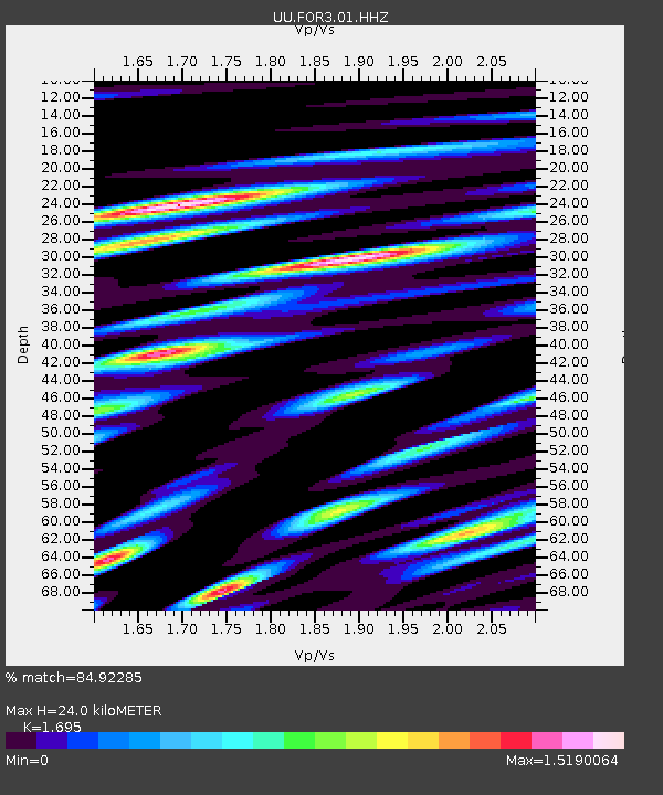
| Estimated Moho Depth: |
24.0 km |
| Estimated Crust Vp/Vs: |
1.70 |
| Assumed Crust Vp: |
6.276 km/s |
| Estimated Crust Vs: |
3.703 km/s |
| Estimated Crust Poisson's Ratio: |
0.23 |
|
| Radial Match: |
84.92285 % |
| Radial Bump: |
400 |
| Transverse Match: |
62.96718 % |
| Transverse Bump: |
400 |
| SOD ConfigId: |
2140511 |
| Insert Time: |
2017-08-06 07:34:59.690 +0000 |
| GWidth: |
2.5 |
| Max Bumps: |
400 |
| Tol: |
0.001 |
|

Signal To Noise
| Channel | StoN | STA | LTA |
| UU:FOR3:01:HHZ:20170723T15:46:52.229988Z | 1.1593173 | 2.1439555E-9 | 1.8493259E-9 |
| UU:FOR3:01:HHN:20170723T15:46:52.229988Z | 1.8874763 | 2.7877378E-9 | 1.4769657E-9 |
| UU:FOR3:01:HHE:20170723T15:46:52.229988Z | 1.6855308 | 2.6859777E-9 | 1.5935502E-9 |
| Arrivals |
| Ps | 2.7 SECOND |
| PpPs | 10.0 SECOND |
| PsPs/PpSs | 13 SECOND |


