You are here: Home > Network List > GS - US Geological Survey Networks Stations List
> Station OK038 West end E0370 Rd, Waynoka, OK, USA > Earthquake Result Viewer
OK038 West end E0370 Rd, Waynoka, OK, USA - Earthquake Result Viewer
| Earthquake location: |
Easter Island Region |
| Earthquake latitude/longitude: |
-22.7/-112.3 |
| Earthquake time(UTC): |
2020/08/15 (228) 06:40:38 GMT |
| Earthquake Depth: |
10 km |
| Earthquake Magnitude: |
5.7 mww |
| Earthquake Catalog/Contributor: |
NEIC PDE/us |
|
| Network: |
GS US Geological Survey Networks |
| Station: |
OK038 West end E0370 Rd, Waynoka, OK, USA |
| Lat/Lon: |
36.48 N/98.74 W |
| Elevation: |
443 m |
|
| Distance: |
60.2 deg |
| Az: |
12.585 deg |
| Baz: |
194.457 deg |
| Ray Param: |
0.061672177 |
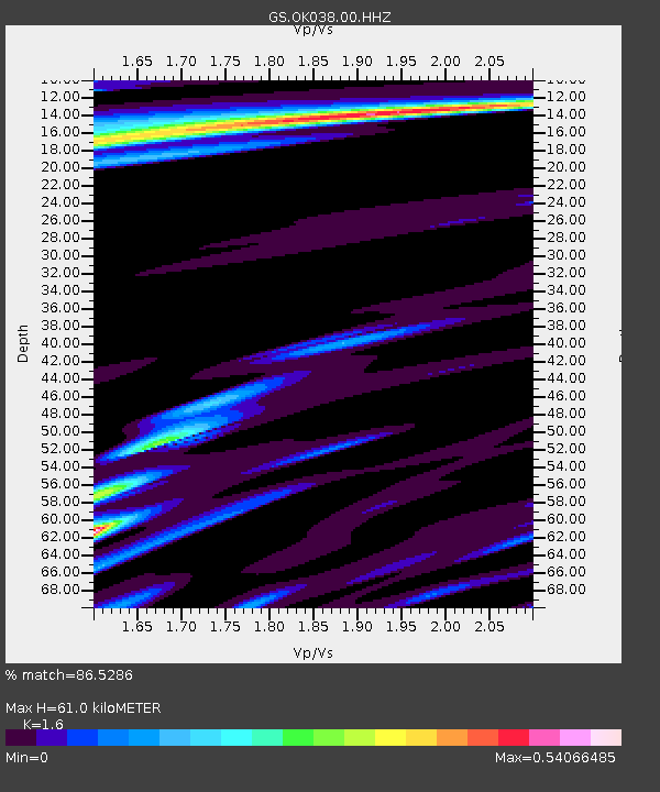
| Estimated Moho Depth: |
61.0 km |
| Estimated Crust Vp/Vs: |
1.60 |
| Assumed Crust Vp: |
6.426 km/s |
| Estimated Crust Vs: |
4.016 km/s |
| Estimated Crust Poisson's Ratio: |
0.18 |
|
| Radial Match: |
86.5286 % |
| Radial Bump: |
400 |
| Transverse Match: |
61.70643 % |
| Transverse Bump: |
400 |
| SOD ConfigId: |
21709731 |
| Insert Time: |
2020-08-29 06:58:18.075 +0000 |
| GWidth: |
2.5 |
| Max Bumps: |
400 |
| Tol: |
0.001 |
|

Signal To Noise
| Channel | StoN | STA | LTA |
| GS:OK038:00:HHZ:20200815T06:50:15.229004Z | 13.458921 | 1.0061304E-6 | 7.4755654E-8 |
| GS:OK038:00:HH1:20200815T06:50:15.229004Z | 3.5851047 | 4.6577279E-7 | 1.2991889E-7 |
| GS:OK038:00:HH2:20200815T06:50:15.229004Z | 0.77110076 | 1.3001956E-7 | 1.6861553E-7 |
| Arrivals |
| Ps | 6.0 SECOND |
| PpPs | 23 SECOND |
| PsPs/PpSs | 29 SECOND |


