You are here: Home > Network List > GS - US Geological Survey Networks Stations List
> Station OK048 Pawnee, OK, Station 48 > Earthquake Result Viewer
OK048 Pawnee, OK, Station 48 - Earthquake Result Viewer
| Earthquake location: |
Easter Island Region |
| Earthquake latitude/longitude: |
-22.7/-112.3 |
| Earthquake time(UTC): |
2020/08/15 (228) 06:40:38 GMT |
| Earthquake Depth: |
10 km |
| Earthquake Magnitude: |
5.7 mww |
| Earthquake Catalog/Contributor: |
NEIC PDE/us |
|
| Network: |
GS US Geological Survey Networks |
| Station: |
OK048 Pawnee, OK, Station 48 |
| Lat/Lon: |
36.42 N/96.94 W |
| Elevation: |
297 m |
|
| Distance: |
60.6 deg |
| Az: |
14.212 deg |
| Baz: |
196.325 deg |
| Ray Param: |
0.06146836 |
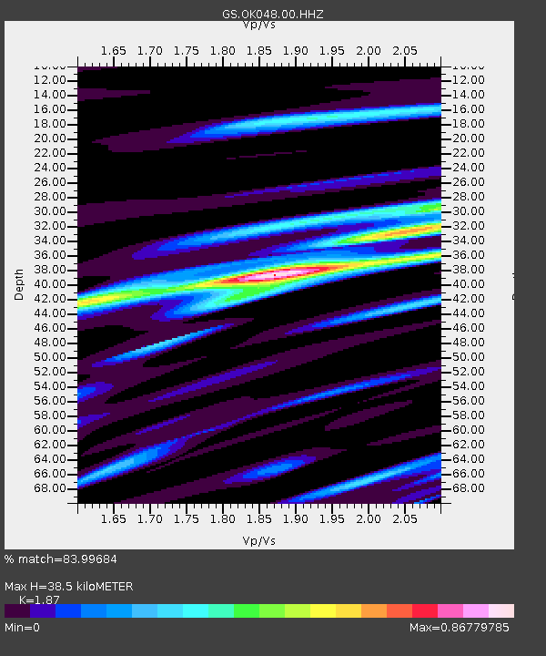
| Estimated Moho Depth: |
38.5 km |
| Estimated Crust Vp/Vs: |
1.87 |
| Assumed Crust Vp: |
6.483 km/s |
| Estimated Crust Vs: |
3.467 km/s |
| Estimated Crust Poisson's Ratio: |
0.30 |
|
| Radial Match: |
83.99684 % |
| Radial Bump: |
400 |
| Transverse Match: |
71.156425 % |
| Transverse Bump: |
400 |
| SOD ConfigId: |
21709731 |
| Insert Time: |
2020-08-29 06:58:20.918 +0000 |
| GWidth: |
2.5 |
| Max Bumps: |
400 |
| Tol: |
0.001 |
|

Signal To Noise
| Channel | StoN | STA | LTA |
| GS:OK048:00:HHZ:20200815T06:50:17.45398Z | 12.579048 | 7.1172065E-7 | 5.657985E-8 |
| GS:OK048:00:HH1:20200815T06:50:17.45398Z | 8.5182295 | 4.2507978E-7 | 4.990236E-8 |
| GS:OK048:00:HH2:20200815T06:50:17.45398Z | 0.928946 | 6.6122475E-8 | 7.1180104E-8 |
| Arrivals |
| Ps | 5.4 SECOND |
| PpPs | 16 SECOND |
| PsPs/PpSs | 22 SECOND |


