You are here: Home > Network List > N4 - Central and EAstern US Network Stations List
> Station G40A Rib Lake, WI, USA > Earthquake Result Viewer
G40A Rib Lake, WI, USA - Earthquake Result Viewer
| Earthquake location: |
Easter Island Region |
| Earthquake latitude/longitude: |
-22.7/-112.3 |
| Earthquake time(UTC): |
2020/08/15 (228) 06:40:38 GMT |
| Earthquake Depth: |
10 km |
| Earthquake Magnitude: |
5.7 mww |
| Earthquake Catalog/Contributor: |
NEIC PDE/us |
|
| Network: |
N4 Central and EAstern US Network |
| Station: |
G40A Rib Lake, WI, USA |
| Lat/Lon: |
45.27 N/90.20 W |
| Elevation: |
472 m |
|
| Distance: |
70.6 deg |
| Az: |
16.372 deg |
| Baz: |
201.631 deg |
| Ray Param: |
0.054908637 |
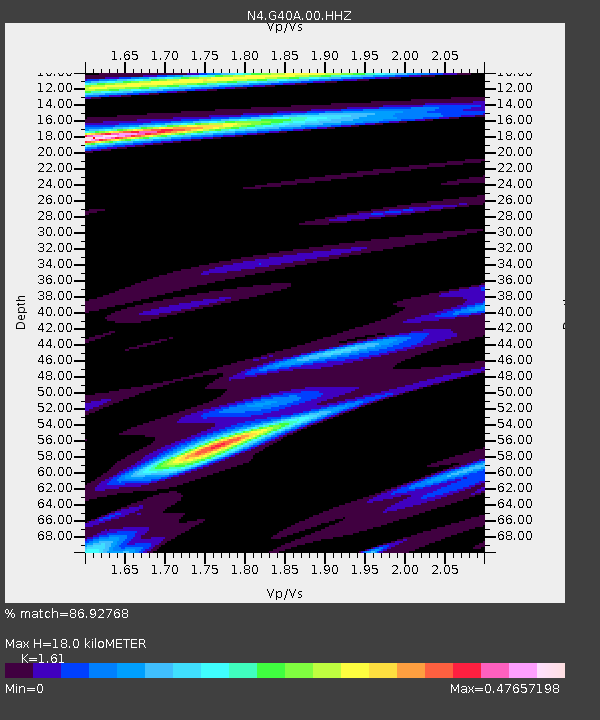
| Estimated Moho Depth: |
18.0 km |
| Estimated Crust Vp/Vs: |
1.61 |
| Assumed Crust Vp: |
6.571 km/s |
| Estimated Crust Vs: |
4.081 km/s |
| Estimated Crust Poisson's Ratio: |
0.19 |
|
| Radial Match: |
86.92768 % |
| Radial Bump: |
400 |
| Transverse Match: |
74.261566 % |
| Transverse Bump: |
400 |
| SOD ConfigId: |
21709731 |
| Insert Time: |
2020-08-29 07:01:27.000 +0000 |
| GWidth: |
2.5 |
| Max Bumps: |
400 |
| Tol: |
0.001 |
|

Signal To Noise
| Channel | StoN | STA | LTA |
| N4:G40A:00:HHZ:20200815T06:51:22.039002Z | 11.791426 | 8.095994E-7 | 6.866001E-8 |
| N4:G40A:00:HH1:20200815T06:51:22.039002Z | 4.61965 | 3.323059E-7 | 7.193313E-8 |
| N4:G40A:00:HH2:20200815T06:51:22.039002Z | 4.470968 | 1.848884E-7 | 4.1353108E-8 |
| Arrivals |
| Ps | 1.7 SECOND |
| PpPs | 6.9 SECOND |
| PsPs/PpSs | 8.6 SECOND |


