You are here: Home > Network List > IU - Global Seismograph Network (GSN - IRIS/USGS) Stations List
> Station PMG Port Moresby, New Guinea > Earthquake Result Viewer
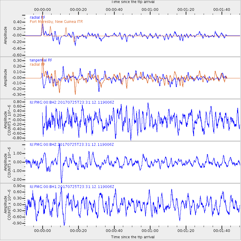
PMG Port Moresby, New Guinea - Earthquake Result Viewer
*The percent match for this event was below the threshold and hence no stack was calculated.
| Earthquake location: |
Southwest Of Sumatra, Indonesia |
| Earthquake latitude/longitude: |
-5.7/101.4 |
| Earthquake time(UTC): |
2017/07/25 (206) 23:23:23 GMT |
| Earthquake Depth: |
10 km |
| Earthquake Magnitude: |
5.5 mb |
| Earthquake Catalog/Contributor: |
NEIC PDE/us |
|
| Network: |
IU Global Seismograph Network (GSN - IRIS/USGS) |
| Station: |
PMG Port Moresby, New Guinea |
| Lat/Lon: |
9.40 S/147.16 E |
| Elevation: |
90 m |
|
| Distance: |
45.5 deg |
| Az: |
97.575 deg |
| Baz: |
271.278 deg |
| Ray Param: |
$rayparam |
*The percent match for this event was below the threshold and hence was not used in the summary stack. |
|
| Radial Match: |
70.46085 % |
| Radial Bump: |
400 |
| Transverse Match: |
65.26921 % |
| Transverse Bump: |
400 |
| SOD ConfigId: |
2140511 |
| Insert Time: |
2017-08-08 15:20:47.313 +0000 |
| GWidth: |
2.5 |
| Max Bumps: |
400 |
| Tol: |
0.001 |
|
Signal To Noise
| Channel | StoN | STA | LTA |
| IU:PMG:00:BHZ:20170725T23:31:12.119006Z | 2.756875 | 6.910621E-7 | 2.5066862E-7 |
| IU:PMG:00:BH1:20170725T23:31:12.119006Z | 1.0806321 | 2.8711563E-7 | 2.656923E-7 |
| IU:PMG:00:BH2:20170725T23:31:12.119006Z | 0.9117572 | 2.5618866E-7 | 2.8098344E-7 |
| Arrivals |
| Ps | |
| PpPs | |
| PsPs/PpSs | |


