You are here: Home > Network List > O2 - Oklahoma Consolidated Temporary Seismic Networks Stations List
> Station FW06 Aline, Oklahoma, USA > Earthquake Result Viewer
FW06 Aline, Oklahoma, USA - Earthquake Result Viewer
| Earthquake location: |
Easter Island Region |
| Earthquake latitude/longitude: |
-22.7/-112.3 |
| Earthquake time(UTC): |
2020/08/15 (228) 06:40:38 GMT |
| Earthquake Depth: |
10 km |
| Earthquake Magnitude: |
5.7 mww |
| Earthquake Catalog/Contributor: |
NEIC PDE/us |
|
| Network: |
O2 Oklahoma Consolidated Temporary Seismic Networks |
| Station: |
FW06 Aline, Oklahoma, USA |
| Lat/Lon: |
36.51 N/98.50 W |
| Elevation: |
420 m |
|
| Distance: |
60.3 deg |
| Az: |
12.793 deg |
| Baz: |
194.704 deg |
| Ray Param: |
0.06162239 |
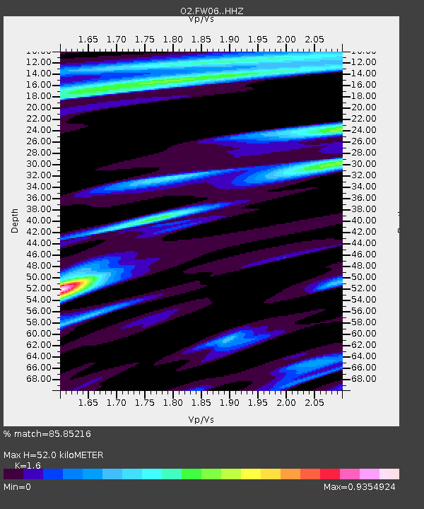
| Estimated Moho Depth: |
52.0 km |
| Estimated Crust Vp/Vs: |
1.60 |
| Assumed Crust Vp: |
6.426 km/s |
| Estimated Crust Vs: |
4.016 km/s |
| Estimated Crust Poisson's Ratio: |
0.18 |
|
| Radial Match: |
85.85216 % |
| Radial Bump: |
394 |
| Transverse Match: |
64.20872 % |
| Transverse Bump: |
400 |
| SOD ConfigId: |
21709731 |
| Insert Time: |
2020-08-29 07:06:37.315 +0000 |
| GWidth: |
2.5 |
| Max Bumps: |
400 |
| Tol: |
0.001 |
|

Signal To Noise
| Channel | StoN | STA | LTA |
| O2:FW06: :HHZ:20200815T06:50:15.799988Z | 8.790211 | 8.8797475E-7 | 1.010186E-7 |
| O2:FW06: :HHN:20200815T06:50:15.799988Z | 4.4317336 | 4.778004E-7 | 1.07813435E-7 |
| O2:FW06: :HHE:20200815T06:50:15.799988Z | 1.257484 | 1.13088056E-7 | 8.9932E-8 |
| Arrivals |
| Ps | 5.1 SECOND |
| PpPs | 20 SECOND |
| PsPs/PpSs | 25 SECOND |


