You are here: Home > Network List > O2 - Oklahoma Consolidated Temporary Seismic Networks Stations List
> Station FW07 Waynoka, Oklahoma, USA > Earthquake Result Viewer
FW07 Waynoka, Oklahoma, USA - Earthquake Result Viewer
| Earthquake location: |
Easter Island Region |
| Earthquake latitude/longitude: |
-22.7/-112.3 |
| Earthquake time(UTC): |
2020/08/15 (228) 06:40:38 GMT |
| Earthquake Depth: |
10 km |
| Earthquake Magnitude: |
5.7 mww |
| Earthquake Catalog/Contributor: |
NEIC PDE/us |
|
| Network: |
O2 Oklahoma Consolidated Temporary Seismic Networks |
| Station: |
FW07 Waynoka, Oklahoma, USA |
| Lat/Lon: |
36.45 N/98.80 W |
| Elevation: |
404 m |
|
| Distance: |
60.2 deg |
| Az: |
12.54 deg |
| Baz: |
194.4 deg |
| Ray Param: |
0.061694823 |
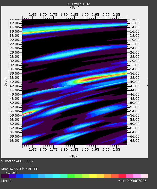
| Estimated Moho Depth: |
55.0 km |
| Estimated Crust Vp/Vs: |
1.62 |
| Assumed Crust Vp: |
6.426 km/s |
| Estimated Crust Vs: |
3.967 km/s |
| Estimated Crust Poisson's Ratio: |
0.19 |
|
| Radial Match: |
86.10857 % |
| Radial Bump: |
400 |
| Transverse Match: |
75.18213 % |
| Transverse Bump: |
400 |
| SOD ConfigId: |
21709731 |
| Insert Time: |
2020-08-29 07:06:39.946 +0000 |
| GWidth: |
2.5 |
| Max Bumps: |
400 |
| Tol: |
0.001 |
|

Signal To Noise
| Channel | StoN | STA | LTA |
| O2:FW07: :HHZ:20200815T06:50:14.960022Z | 9.4728365 | 1.0117993E-6 | 1.06810596E-7 |
| O2:FW07: :HHN:20200815T06:50:14.960022Z | 4.171047 | 4.4754879E-7 | 1.0729891E-7 |
| O2:FW07: :HHE:20200815T06:50:14.960022Z | 2.1719239 | 2.0607364E-7 | 9.488069E-8 |
| Arrivals |
| Ps | 5.6 SECOND |
| PpPs | 21 SECOND |
| PsPs/PpSs | 27 SECOND |


