You are here: Home > Network List > O2 - Oklahoma Consolidated Temporary Seismic Networks Stations List
> Station PW10 Pawnee, Oklahoma > Earthquake Result Viewer
PW10 Pawnee, Oklahoma - Earthquake Result Viewer
| Earthquake location: |
Easter Island Region |
| Earthquake latitude/longitude: |
-22.7/-112.3 |
| Earthquake time(UTC): |
2020/08/15 (228) 06:40:38 GMT |
| Earthquake Depth: |
10 km |
| Earthquake Magnitude: |
5.7 mww |
| Earthquake Catalog/Contributor: |
NEIC PDE/us |
|
| Network: |
O2 Oklahoma Consolidated Temporary Seismic Networks |
| Station: |
PW10 Pawnee, Oklahoma |
| Lat/Lon: |
36.37 N/96.83 W |
| Elevation: |
297 m |
|
| Distance: |
60.5 deg |
| Az: |
14.328 deg |
| Baz: |
196.449 deg |
| Ray Param: |
0.061483253 |
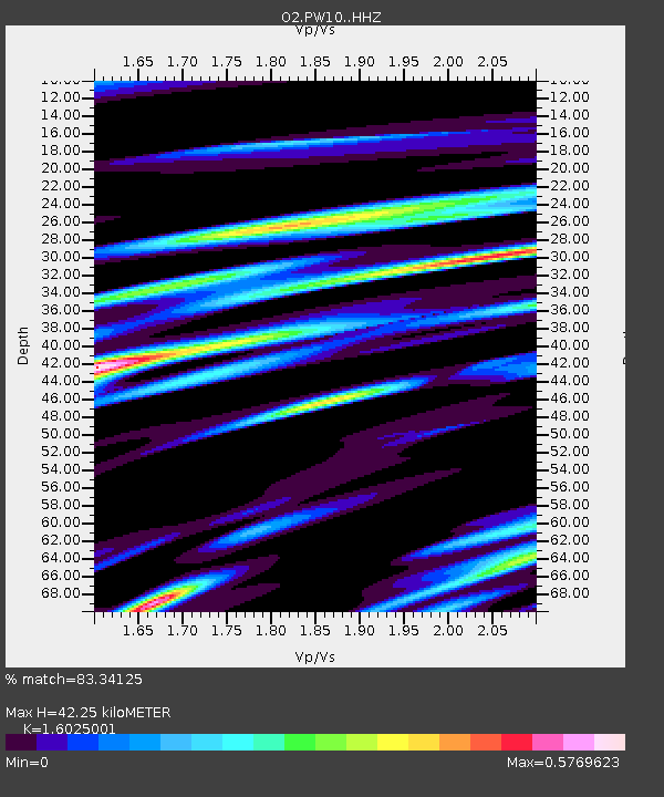
| Estimated Moho Depth: |
42.25 km |
| Estimated Crust Vp/Vs: |
1.60 |
| Assumed Crust Vp: |
6.483 km/s |
| Estimated Crust Vs: |
4.045 km/s |
| Estimated Crust Poisson's Ratio: |
0.18 |
|
| Radial Match: |
83.34125 % |
| Radial Bump: |
400 |
| Transverse Match: |
74.11477 % |
| Transverse Bump: |
400 |
| SOD ConfigId: |
21709731 |
| Insert Time: |
2020-08-29 07:07:02.887 +0000 |
| GWidth: |
2.5 |
| Max Bumps: |
400 |
| Tol: |
0.001 |
|

Signal To Noise
| Channel | StoN | STA | LTA |
| O2:PW10: :HHZ:20200815T06:50:17.289979Z | 11.927624 | 6.5550586E-7 | 5.4956956E-8 |
| O2:PW10: :HHN:20200815T06:50:17.289979Z | 5.861115 | 4.0453716E-7 | 6.9020516E-8 |
| O2:PW10: :HHE:20200815T06:50:17.289979Z | 1.5243098 | 1.0472385E-7 | 6.870248E-8 |
| Arrivals |
| Ps | 4.1 SECOND |
| PpPs | 16 SECOND |
| PsPs/PpSs | 20 SECOND |


