You are here: Home > Network List > O2 - Oklahoma Consolidated Temporary Seismic Networks Stations List
> Station PW13 Pawnee, Oklahoma, USA > Earthquake Result Viewer
PW13 Pawnee, Oklahoma, USA - Earthquake Result Viewer
| Earthquake location: |
Easter Island Region |
| Earthquake latitude/longitude: |
-22.7/-112.3 |
| Earthquake time(UTC): |
2020/08/15 (228) 06:40:38 GMT |
| Earthquake Depth: |
10 km |
| Earthquake Magnitude: |
5.7 mww |
| Earthquake Catalog/Contributor: |
NEIC PDE/us |
|
| Network: |
O2 Oklahoma Consolidated Temporary Seismic Networks |
| Station: |
PW13 Pawnee, Oklahoma, USA |
| Lat/Lon: |
36.33 N/96.82 W |
| Elevation: |
290 m |
|
| Distance: |
60.5 deg |
| Az: |
14.352 deg |
| Baz: |
196.468 deg |
| Ray Param: |
0.06150431 |
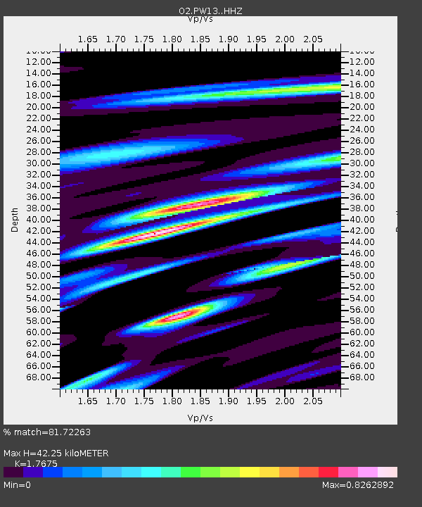
| Estimated Moho Depth: |
42.25 km |
| Estimated Crust Vp/Vs: |
1.77 |
| Assumed Crust Vp: |
6.483 km/s |
| Estimated Crust Vs: |
3.668 km/s |
| Estimated Crust Poisson's Ratio: |
0.26 |
|
| Radial Match: |
81.72263 % |
| Radial Bump: |
400 |
| Transverse Match: |
71.67858 % |
| Transverse Bump: |
400 |
| SOD ConfigId: |
21709731 |
| Insert Time: |
2020-08-29 07:07:05.088 +0000 |
| GWidth: |
2.5 |
| Max Bumps: |
400 |
| Tol: |
0.001 |
|

Signal To Noise
| Channel | StoN | STA | LTA |
| O2:PW13: :HHZ:20200815T06:50:17.075013Z | 17.386278 | 7.2536204E-7 | 4.1720376E-8 |
| O2:PW13: :HHN:20200815T06:50:17.075013Z | 6.4303765 | 3.8833213E-7 | 6.039026E-8 |
| O2:PW13: :HHE:20200815T06:50:17.075013Z | 2.5635417 | 1.5338783E-7 | 5.983434E-8 |
| Arrivals |
| Ps | 5.2 SECOND |
| PpPs | 17 SECOND |
| PsPs/PpSs | 22 SECOND |


