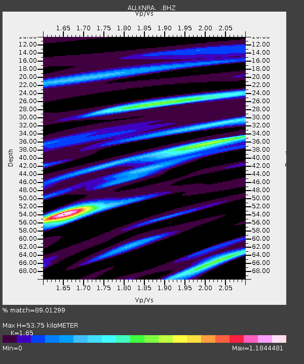
KNRA Kunnunarra, Western Australia - Earthquake Result Viewer

Earthquake location: Southern Sumatra, Indonesia
Earthquake latitude/longitude: -1.5/99.5
Earthquake time(UTC): 2009/08/16 (228) 07:38:21 GMT
Earthquake Depth: 20 km
Earthquake Magnitude: 6.5 MB, 6.7 MS, 6.7 MW, 6.5 MW
Earthquake Catalog/Contributor: WHDF/NEIC
Network: AU Australian Seismological Centre
Station: KNRA Kunnunarra, Western Australia
Lat/Lon: 15.68 S/128.76 E
Elevation: 101 m
Distance: 32.1 deg
Az: 117.664 deg
Baz: 293.197 deg
Ray Param: 0.07876424
Estimated Moho Depth: 53.75 km
Estimated Crust Vp/Vs: 1.65
Assumed Crust Vp: 6.397 km/s
Estimated Crust Vs: 3.877 km/s
Estimated Crust Poisson's Ratio: 0.21
Radial Match: 89.01299 %
Radial Bump: 313
Transverse Match: 45.879936 %
Transverse Bump: 400
SOD ConfigId: 2622
Insert Time: 2010-03-09 00:03:05.712 +0000
GWidth: 2.5
Max Bumps: 400
Tol: 0.001

Signal To Noise

ChannelStoNSTALTA
AU:KNRA: :BHZ:20090816T07:44:17.068988Z3.54923221.2487159E-63.5182705E-7
AU:KNRA: :BHN:20090816T07:44:17.068988Z1.48645823.9929E-72.6861838E-7
AU:KNRA: :BHE:20090816T07:44:17.068988Z2.01879338.102813E-74.013691E-7
Arrivals
Ps5.9 SECOND
PpPs20 SECOND
PsPs/PpSs26 SECOND