You are here: Home > Network List > AU - Australian Seismological Centre Stations List
> Station KNRA Kunnunarra, Western Australia > Earthquake Result Viewer
KNRA Kunnunarra, Western Australia - Earthquake Result Viewer
| Earthquake location: |
Samoa Islands Region |
| Earthquake latitude/longitude: |
-15.5/-172.1 |
| Earthquake time(UTC): |
2009/09/29 (272) 17:48:10 GMT |
| Earthquake Depth: |
18 km |
| Earthquake Magnitude: |
7.1 MB, 8.1 MS, 8.1 MW, 8.0 MW |
| Earthquake Catalog/Contributor: |
WHDF/NEIC |
|
| Network: |
AU Australian Seismological Centre |
| Station: |
KNRA Kunnunarra, Western Australia |
| Lat/Lon: |
15.68 S/128.76 E |
| Elevation: |
101 m |
|
| Distance: |
56.8 deg |
| Az: |
261.216 deg |
| Baz: |
98.443 deg |
| Ray Param: |
0.06388836 |
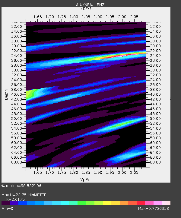
| Estimated Moho Depth: |
23.75 km |
| Estimated Crust Vp/Vs: |
2.02 |
| Assumed Crust Vp: |
6.397 km/s |
| Estimated Crust Vs: |
3.171 km/s |
| Estimated Crust Poisson's Ratio: |
0.34 |
|
| Radial Match: |
98.532196 % |
| Radial Bump: |
277 |
| Transverse Match: |
91.11301 % |
| Transverse Bump: |
400 |
| SOD ConfigId: |
2622 |
| Insert Time: |
2010-03-09 00:03:10.813 +0000 |
| GWidth: |
2.5 |
| Max Bumps: |
400 |
| Tol: |
0.001 |
|

Signal To Noise
| Channel | StoN | STA | LTA |
| AU:KNRA: :BHZ:20090929T17:57:23.020029Z | 4.73325 | 1.1666855E-6 | 2.464872E-7 |
| AU:KNRA: :BHN:20090929T17:57:23.020029Z | 1.6698714 | 2.412483E-7 | 1.4447119E-7 |
| AU:KNRA: :BHE:20090929T17:57:23.020029Z | 2.4731278 | 5.576601E-7 | 2.2548777E-7 |
| Arrivals |
| Ps | 3.9 SECOND |
| PpPs | 11 SECOND |
| PsPs/PpSs | 15 SECOND |


