You are here: Home > Network List > IU - Global Seismograph Network (GSN - IRIS/USGS) Stations List
> Station CTAO Charters Towers, Australia > Earthquake Result Viewer
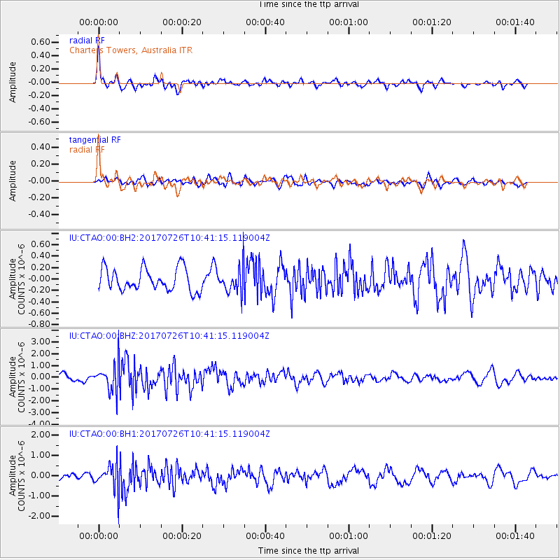
CTAO Charters Towers, Australia - Earthquake Result Viewer
*The percent match for this event was below the threshold and hence no stack was calculated.
| Earthquake location: |
Southeast Of Ryukyu Islands |
| Earthquake latitude/longitude: |
26.9/130.2 |
| Earthquake time(UTC): |
2017/07/26 (207) 10:32:57 GMT |
| Earthquake Depth: |
10 km |
| Earthquake Magnitude: |
5.9 Mww |
| Earthquake Catalog/Contributor: |
NEIC PDE/us |
|
| Network: |
IU Global Seismograph Network (GSN - IRIS/USGS) |
| Station: |
CTAO Charters Towers, Australia |
| Lat/Lon: |
20.09 S/146.25 E |
| Elevation: |
357 m |
|
| Distance: |
49.3 deg |
| Az: |
159.922 deg |
| Baz: |
340.967 deg |
| Ray Param: |
$rayparam |
*The percent match for this event was below the threshold and hence was not used in the summary stack. |
|
| Radial Match: |
79.40897 % |
| Radial Bump: |
400 |
| Transverse Match: |
63.028652 % |
| Transverse Bump: |
400 |
| SOD ConfigId: |
2140511 |
| Insert Time: |
2017-08-09 02:27:06.258 +0000 |
| GWidth: |
2.5 |
| Max Bumps: |
400 |
| Tol: |
0.001 |
|
Signal To Noise
| Channel | StoN | STA | LTA |
| IU:CTAO:00:BHZ:20170726T10:41:15.119004Z | 4.533149 | 1.2039445E-6 | 2.655868E-7 |
| IU:CTAO:00:BH1:20170726T10:41:15.119004Z | 4.6776323 | 6.488512E-7 | 1.387136E-7 |
| IU:CTAO:00:BH2:20170726T10:41:15.119004Z | 1.1817214 | 2.3159596E-7 | 1.9598185E-7 |
| Arrivals |
| Ps | |
| PpPs | |
| PsPs/PpSs | |


