You are here: Home > Network List > TX - Texas Seismological Network Stations List
> Station PB11 China Draw > Earthquake Result Viewer
PB11 China Draw - Earthquake Result Viewer
| Earthquake location: |
Easter Island Region |
| Earthquake latitude/longitude: |
-22.7/-112.3 |
| Earthquake time(UTC): |
2020/08/15 (228) 06:40:38 GMT |
| Earthquake Depth: |
10 km |
| Earthquake Magnitude: |
5.7 mww |
| Earthquake Catalog/Contributor: |
NEIC PDE/us |
|
| Network: |
TX Texas Seismological Network |
| Station: |
PB11 China Draw |
| Lat/Lon: |
31.94 N/104.03 W |
| Elevation: |
915 m |
|
| Distance: |
54.9 deg |
| Az: |
8.607 deg |
| Baz: |
189.355 deg |
| Ray Param: |
0.065161034 |
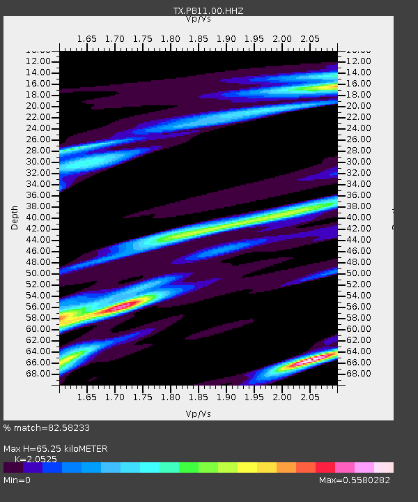
| Estimated Moho Depth: |
65.25 km |
| Estimated Crust Vp/Vs: |
2.05 |
| Assumed Crust Vp: |
6.361 km/s |
| Estimated Crust Vs: |
3.099 km/s |
| Estimated Crust Poisson's Ratio: |
0.34 |
|
| Radial Match: |
82.58233 % |
| Radial Bump: |
400 |
| Transverse Match: |
73.716675 % |
| Transverse Bump: |
400 |
| SOD ConfigId: |
21709731 |
| Insert Time: |
2020-08-29 07:16:12.681 +0000 |
| GWidth: |
2.5 |
| Max Bumps: |
400 |
| Tol: |
0.001 |
|

Signal To Noise
| Channel | StoN | STA | LTA |
| TX:PB11:00:HHZ:20200815T06:49:37.710022Z | 11.563121 | 1.037692E-6 | 8.9741505E-8 |
| TX:PB11:00:HH1:20200815T06:49:37.710022Z | 6.003196 | 3.1515103E-7 | 5.249721E-8 |
| TX:PB11:00:HH2:20200815T06:49:37.710022Z | 1.4033715 | 7.1538224E-8 | 5.0975974E-8 |
| Arrivals |
| Ps | 11 SECOND |
| PpPs | 30 SECOND |
| PsPs/PpSs | 41 SECOND |


