You are here: Home > Network List > TX - Texas Seismological Network Stations List
> Station PLPT Palo Pinto > Earthquake Result Viewer
PLPT Palo Pinto - Earthquake Result Viewer
| Earthquake location: |
Easter Island Region |
| Earthquake latitude/longitude: |
-22.7/-112.3 |
| Earthquake time(UTC): |
2020/08/15 (228) 06:40:38 GMT |
| Earthquake Depth: |
10 km |
| Earthquake Magnitude: |
5.7 mww |
| Earthquake Catalog/Contributor: |
NEIC PDE/us |
|
| Network: |
TX Texas Seismological Network |
| Station: |
PLPT Palo Pinto |
| Lat/Lon: |
32.81 N/98.32 W |
| Elevation: |
336 m |
|
| Distance: |
56.8 deg |
| Az: |
14.091 deg |
| Baz: |
195.486 deg |
| Ray Param: |
0.06391417 |
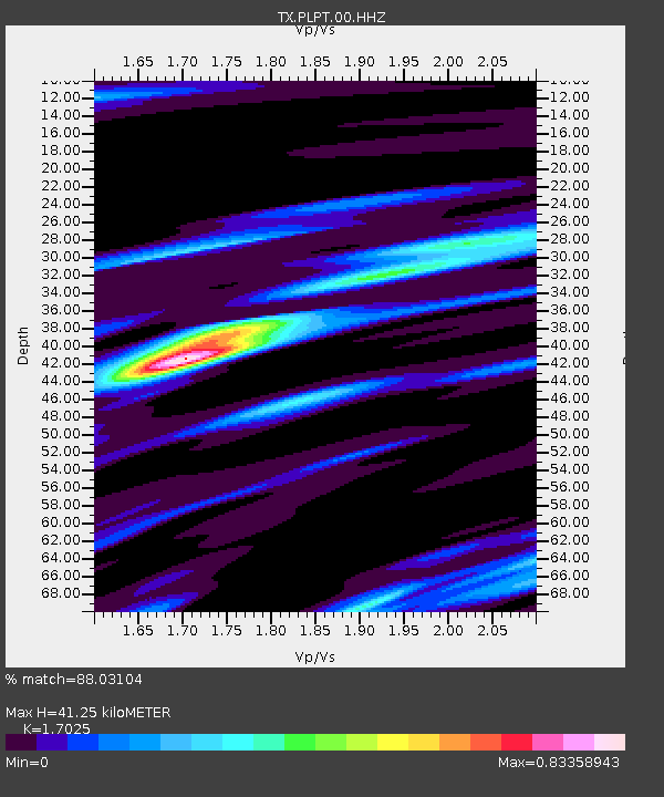
| Estimated Moho Depth: |
41.25 km |
| Estimated Crust Vp/Vs: |
1.70 |
| Assumed Crust Vp: |
6.426 km/s |
| Estimated Crust Vs: |
3.775 km/s |
| Estimated Crust Poisson's Ratio: |
0.24 |
|
| Radial Match: |
88.03104 % |
| Radial Bump: |
313 |
| Transverse Match: |
81.26088 % |
| Transverse Bump: |
361 |
| SOD ConfigId: |
21709731 |
| Insert Time: |
2020-08-29 07:16:32.998 +0000 |
| GWidth: |
2.5 |
| Max Bumps: |
400 |
| Tol: |
0.001 |
|

Signal To Noise
| Channel | StoN | STA | LTA |
| TX:PLPT:00:HHZ:20200815T06:49:51.27002Z | 16.91313 | 9.716427E-7 | 5.7449018E-8 |
| TX:PLPT:00:HH1:20200815T06:49:51.27002Z | 5.436872 | 2.5600394E-7 | 4.7086623E-8 |
| TX:PLPT:00:HH2:20200815T06:49:51.27002Z | 10.774091 | 4.465796E-7 | 4.14494E-8 |
| Arrivals |
| Ps | 4.8 SECOND |
| PpPs | 16 SECOND |
| PsPs/PpSs | 21 SECOND |


