You are here: Home > Network List > TX - Texas Seismological Network Stations List
> Station SGCY Sterling City > Earthquake Result Viewer
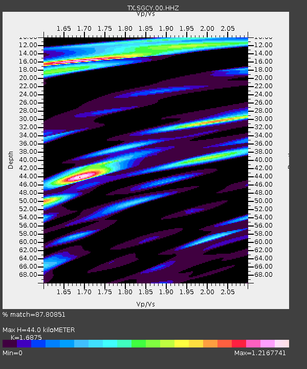
SGCY Sterling City - Earthquake Result Viewer
| Earthquake location: |
Easter Island Region |
| Earthquake latitude/longitude: |
-22.7/-112.3 |
| Earthquake time(UTC): |
2020/08/15 (228) 06:40:38 GMT |
| Earthquake Depth: |
10 km |
| Earthquake Magnitude: |
5.7 mww |
| Earthquake Catalog/Contributor: |
NEIC PDE/us |
|
| Network: |
TX Texas Seismological Network |
| Station: |
SGCY Sterling City |
| Lat/Lon: |
31.91 N/101.13 W |
| Elevation: |
776 m |
|
| Distance: |
55.3 deg |
| Az: |
11.571 deg |
| Baz: |
192.581 deg |
| Ray Param: |
0.0648565 |
| Estimated Moho Depth: |
44.0 km |
| Estimated Crust Vp/Vs: |
1.69 |
| Assumed Crust Vp: |
6.38 km/s |
| Estimated Crust Vs: |
3.781 km/s |
| Estimated Crust Poisson's Ratio: |
0.23 |
|
| Radial Match: |
87.80851 % |
| Radial Bump: |
400 |
| Transverse Match: |
60.250282 % |
| Transverse Bump: |
400 |
| SOD ConfigId: |
21709731 |
| Insert Time: |
2020-08-29 07:16:39.182 +0000 |
| GWidth: |
2.5 |
| Max Bumps: |
400 |
| Tol: |
0.001 |
|

Signal To Noise
| Channel | StoN | STA | LTA |
| TX:SGCY:00:HHZ:20200815T06:49:40.950013Z | 12.168782 | 9.699136E-7 | 7.970506E-8 |
| TX:SGCY:00:HH1:20200815T06:49:40.950013Z | 1.3550001 | 8.816485E-8 | 6.50663E-8 |
| TX:SGCY:00:HH2:20200815T06:49:40.950013Z | 7.491657 | 5.204941E-7 | 6.94765E-8 |
| Arrivals |
| Ps | 5.0 SECOND |
| PpPs | 18 SECOND |
| PsPs/PpSs | 23 SECOND |


