You are here: Home > Network List > TX - Texas Seismological Network Stations List
> Station SNAG San Augustine > Earthquake Result Viewer
SNAG San Augustine - Earthquake Result Viewer
| Earthquake location: |
Easter Island Region |
| Earthquake latitude/longitude: |
-22.7/-112.3 |
| Earthquake time(UTC): |
2020/08/15 (228) 06:40:38 GMT |
| Earthquake Depth: |
10 km |
| Earthquake Magnitude: |
5.7 mww |
| Earthquake Catalog/Contributor: |
NEIC PDE/us |
|
| Network: |
TX Texas Seismological Network |
| Station: |
SNAG San Augustine |
| Lat/Lon: |
31.52 N/94.18 W |
| Elevation: |
84 m |
|
| Distance: |
56.6 deg |
| Az: |
18.559 deg |
| Baz: |
200.132 deg |
| Ray Param: |
0.06401756 |
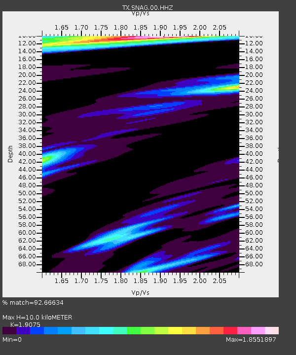
| Estimated Moho Depth: |
10.0 km |
| Estimated Crust Vp/Vs: |
1.91 |
| Assumed Crust Vp: |
5.738 km/s |
| Estimated Crust Vs: |
3.008 km/s |
| Estimated Crust Poisson's Ratio: |
0.31 |
|
| Radial Match: |
92.66634 % |
| Radial Bump: |
307 |
| Transverse Match: |
72.61146 % |
| Transverse Bump: |
296 |
| SOD ConfigId: |
21709731 |
| Insert Time: |
2020-08-29 07:16:51.603 +0000 |
| GWidth: |
2.5 |
| Max Bumps: |
400 |
| Tol: |
0.001 |
|
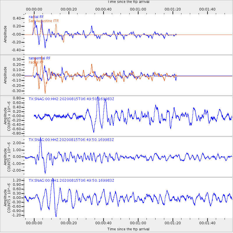
Signal To Noise
| Channel | StoN | STA | LTA |
| TX:SNAG:00:HHZ:20200815T06:49:50.169983Z | 11.329622 | 1.0837941E-6 | 9.566022E-8 |
| TX:SNAG:00:HH1:20200815T06:49:50.169983Z | 3.57774 | 3.4983702E-7 | 9.778157E-8 |
| TX:SNAG:00:HH2:20200815T06:49:50.169983Z | 4.6982656 | 3.2417185E-7 | 6.899819E-8 |
| Arrivals |
| Ps | 1.6 SECOND |
| PpPs | 4.9 SECOND |
| PsPs/PpSs | 6.5 SECOND |


